You are here: Home > Network List > TA - USArray Transportable Network (new EarthScope stations) Stations List
> Station W48A Pulaski, TN, USA > Earthquake Result Viewer
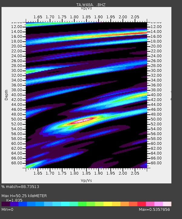
W48A Pulaski, TN, USA - Earthquake Result Viewer
| Earthquake location: |
Hokkaido, Japan Region |
| Earthquake latitude/longitude: |
42.8/143.1 |
| Earthquake time(UTC): |
2013/02/02 (033) 14:17:35 GMT |
| Earthquake Depth: |
107 km |
| Earthquake Magnitude: |
6.4 MB, 6.9 MW, 6.9 MW |
| Earthquake Catalog/Contributor: |
WHDF/NEIC |
|
| Network: |
TA USArray Transportable Network (new EarthScope stations) |
| Station: |
W48A Pulaski, TN, USA |
| Lat/Lon: |
35.14 N/86.93 W |
| Elevation: |
260 m |
|
| Distance: |
90.0 deg |
| Az: |
38.907 deg |
| Baz: |
325.647 deg |
| Ray Param: |
0.04168325 |
| Estimated Moho Depth: |
50.25 km |
| Estimated Crust Vp/Vs: |
1.84 |
| Assumed Crust Vp: |
6.476 km/s |
| Estimated Crust Vs: |
3.529 km/s |
| Estimated Crust Poisson's Ratio: |
0.29 |
|
| Radial Match: |
88.73513 % |
| Radial Bump: |
350 |
| Transverse Match: |
68.25336 % |
| Transverse Bump: |
400 |
| SOD ConfigId: |
494114 |
| Insert Time: |
2013-04-27 06:44:50.846 +0000 |
| GWidth: |
2.5 |
| Max Bumps: |
400 |
| Tol: |
0.001 |
|

Signal To Noise
| Channel | StoN | STA | LTA |
| TA:W48A: :BHZ:20130202T14:29:51.40002Z | 9.760488 | 2.0301868E-6 | 2.0800056E-7 |
| TA:W48A: :BHN:20130202T14:29:51.40002Z | 2.826495 | 6.694483E-7 | 2.3684753E-7 |
| TA:W48A: :BHE:20130202T14:29:51.40002Z | 3.0850034 | 5.162295E-7 | 1.6733513E-7 |
| Arrivals |
| Ps | 6.6 SECOND |
| PpPs | 22 SECOND |
| PsPs/PpSs | 28 SECOND |


