You are here: Home > Network List > TA - USArray Transportable Network (new EarthScope stations) Stations List
> Station 452A Marianna, FL, USA > Earthquake Result Viewer
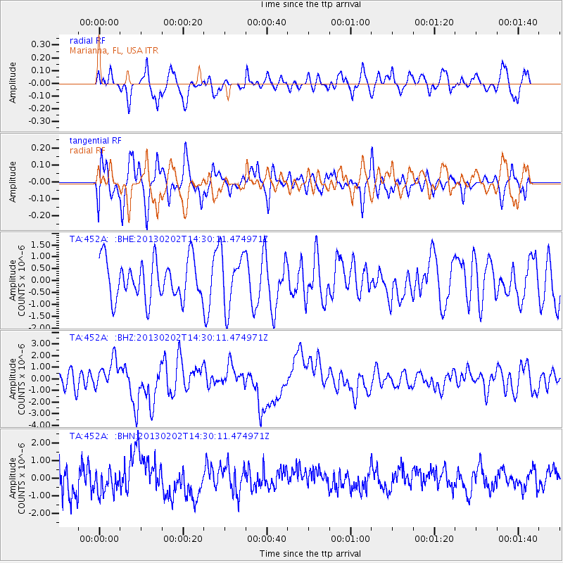
452A Marianna, FL, USA - Earthquake Result Viewer
*The percent match for this event was below the threshold and hence no stack was calculated.
| Earthquake location: |
Hokkaido, Japan Region |
| Earthquake latitude/longitude: |
42.8/143.1 |
| Earthquake time(UTC): |
2013/02/02 (033) 14:17:35 GMT |
| Earthquake Depth: |
107 km |
| Earthquake Magnitude: |
6.4 MB, 6.9 MW, 6.9 MW |
| Earthquake Catalog/Contributor: |
WHDF/NEIC |
|
| Network: |
TA USArray Transportable Network (new EarthScope stations) |
| Station: |
452A Marianna, FL, USA |
| Lat/Lon: |
30.85 N/85.18 W |
| Elevation: |
35 m |
|
| Distance: |
94.4 deg |
| Az: |
40.072 deg |
| Baz: |
326.552 deg |
| Ray Param: |
$rayparam |
*The percent match for this event was below the threshold and hence was not used in the summary stack. |
|
| Radial Match: |
52.723717 % |
| Radial Bump: |
400 |
| Transverse Match: |
54.584538 % |
| Transverse Bump: |
400 |
| SOD ConfigId: |
494114 |
| Insert Time: |
2013-04-27 06:46:03.532 +0000 |
| GWidth: |
2.5 |
| Max Bumps: |
400 |
| Tol: |
0.001 |
|
Signal To Noise
| Channel | StoN | STA | LTA |
| TA:452A: :BHZ:20130202T14:30:11.474971Z | 1.7646848 | 1.316761E-6 | 7.461735E-7 |
| TA:452A: :BHN:20130202T14:30:11.474971Z | 0.6678518 | 6.205767E-7 | 9.292132E-7 |
| TA:452A: :BHE:20130202T14:30:11.474971Z | 1.3539529 | 1.1146333E-6 | 8.232438E-7 |
| Arrivals |
| Ps | |
| PpPs | |
| PsPs/PpSs | |


