You are here: Home > Network List > TA - USArray Transportable Network (new EarthScope stations) Stations List
> Station 154A Montrose, GA, USA > Earthquake Result Viewer
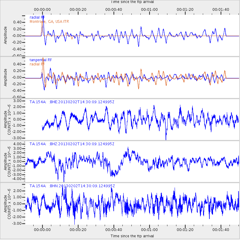
154A Montrose, GA, USA - Earthquake Result Viewer
*The percent match for this event was below the threshold and hence no stack was calculated.
| Earthquake location: |
Hokkaido, Japan Region |
| Earthquake latitude/longitude: |
42.8/143.1 |
| Earthquake time(UTC): |
2013/02/02 (033) 14:17:35 GMT |
| Earthquake Depth: |
107 km |
| Earthquake Magnitude: |
6.4 MB, 6.9 MW, 6.9 MW |
| Earthquake Catalog/Contributor: |
WHDF/NEIC |
|
| Network: |
TA USArray Transportable Network (new EarthScope stations) |
| Station: |
154A Montrose, GA, USA |
| Lat/Lon: |
32.61 N/83.11 W |
| Elevation: |
111 m |
|
| Distance: |
93.9 deg |
| Az: |
37.626 deg |
| Baz: |
327.814 deg |
| Ray Param: |
$rayparam |
*The percent match for this event was below the threshold and hence was not used in the summary stack. |
|
| Radial Match: |
58.750828 % |
| Radial Bump: |
400 |
| Transverse Match: |
39.971325 % |
| Transverse Bump: |
400 |
| SOD ConfigId: |
494114 |
| Insert Time: |
2013-04-27 06:47:18.496 +0000 |
| GWidth: |
2.5 |
| Max Bumps: |
400 |
| Tol: |
0.001 |
|
Signal To Noise
| Channel | StoN | STA | LTA |
| TA:154A: :BHZ:20130202T14:30:09.124995Z | 3.2677712 | 1.2603034E-6 | 3.8567677E-7 |
| TA:154A: :BHN:20130202T14:30:09.124995Z | 0.7250418 | 8.443929E-7 | 1.1646127E-6 |
| TA:154A: :BHE:20130202T14:30:09.124995Z | 0.6721752 | 5.504774E-7 | 8.189492E-7 |
| Arrivals |
| Ps | |
| PpPs | |
| PsPs/PpSs | |


