You are here: Home > Network List > TA - USArray Transportable Network (new EarthScope stations) Stations List
> Station Z51A Franklin, GA, USA > Earthquake Result Viewer
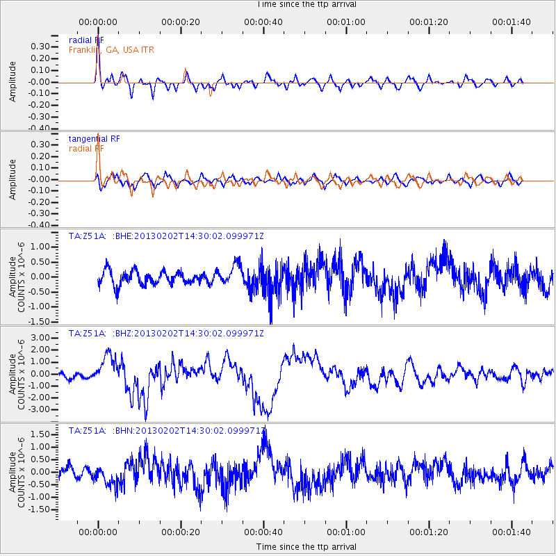
Z51A Franklin, GA, USA - Earthquake Result Viewer
*The percent match for this event was below the threshold and hence no stack was calculated.
| Earthquake location: |
Hokkaido, Japan Region |
| Earthquake latitude/longitude: |
42.8/143.1 |
| Earthquake time(UTC): |
2013/02/02 (033) 14:17:35 GMT |
| Earthquake Depth: |
107 km |
| Earthquake Magnitude: |
6.4 MB, 6.9 MW, 6.9 MW |
| Earthquake Catalog/Contributor: |
WHDF/NEIC |
|
| Network: |
TA USArray Transportable Network (new EarthScope stations) |
| Station: |
Z51A Franklin, GA, USA |
| Lat/Lon: |
33.32 N/85.17 W |
| Elevation: |
249 m |
|
| Distance: |
92.3 deg |
| Az: |
38.71 deg |
| Baz: |
326.636 deg |
| Ray Param: |
$rayparam |
*The percent match for this event was below the threshold and hence was not used in the summary stack. |
|
| Radial Match: |
77.15186 % |
| Radial Bump: |
400 |
| Transverse Match: |
62.785225 % |
| Transverse Bump: |
400 |
| SOD ConfigId: |
494114 |
| Insert Time: |
2013-04-27 06:48:10.652 +0000 |
| GWidth: |
2.5 |
| Max Bumps: |
400 |
| Tol: |
0.001 |
|
Signal To Noise
| Channel | StoN | STA | LTA |
| TA:Z51A: :BHZ:20130202T14:30:02.099971Z | 4.348588 | 1.2992983E-6 | 2.9878623E-7 |
| TA:Z51A: :BHN:20130202T14:30:02.099971Z | 1.3682902 | 3.9540308E-7 | 2.8897603E-7 |
| TA:Z51A: :BHE:20130202T14:30:02.099971Z | 1.5145609 | 3.4316292E-7 | 2.2657584E-7 |
| Arrivals |
| Ps | |
| PpPs | |
| PsPs/PpSs | |


