You are here: Home > Network List > TA - USArray Transportable Network (new EarthScope stations) Stations List
> Station X53A Estanollee, GA, USA > Earthquake Result Viewer
X53A Estanollee, GA, USA - Earthquake Result Viewer
| Earthquake location: |
Hokkaido, Japan Region |
| Earthquake latitude/longitude: |
42.8/143.1 |
| Earthquake time(UTC): |
2013/02/02 (033) 14:17:35 GMT |
| Earthquake Depth: |
107 km |
| Earthquake Magnitude: |
6.4 MB, 6.9 MW, 6.9 MW |
| Earthquake Catalog/Contributor: |
WHDF/NEIC |
|
| Network: |
TA USArray Transportable Network (new EarthScope stations) |
| Station: |
X53A Estanollee, GA, USA |
| Lat/Lon: |
34.50 N/83.30 W |
| Elevation: |
240 m |
|
| Distance: |
92.2 deg |
| Az: |
36.758 deg |
| Baz: |
327.753 deg |
| Ray Param: |
0.041452512 |
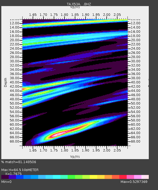
| Estimated Moho Depth: |
64.5 km |
| Estimated Crust Vp/Vs: |
1.77 |
| Assumed Crust Vp: |
6.35 km/s |
| Estimated Crust Vs: |
3.593 km/s |
| Estimated Crust Poisson's Ratio: |
0.26 |
|
| Radial Match: |
81.148506 % |
| Radial Bump: |
400 |
| Transverse Match: |
70.14299 % |
| Transverse Bump: |
400 |
| SOD ConfigId: |
494114 |
| Insert Time: |
2013-04-27 06:48:34.300 +0000 |
| GWidth: |
2.5 |
| Max Bumps: |
400 |
| Tol: |
0.001 |
|

Signal To Noise
| Channel | StoN | STA | LTA |
| TA:X53A: :BHZ:20130202T14:30:01.424983Z | 5.009494 | 1.5585833E-6 | 3.1112592E-7 |
| TA:X53A: :BHN:20130202T14:30:01.424983Z | 2.1793883 | 5.430623E-7 | 2.4918106E-7 |
| TA:X53A: :BHE:20130202T14:30:01.424983Z | 1.0213137 | 2.2818558E-7 | 2.2342363E-7 |
| Arrivals |
| Ps | 8.0 SECOND |
| PpPs | 28 SECOND |
| PsPs/PpSs | 36 SECOND |


