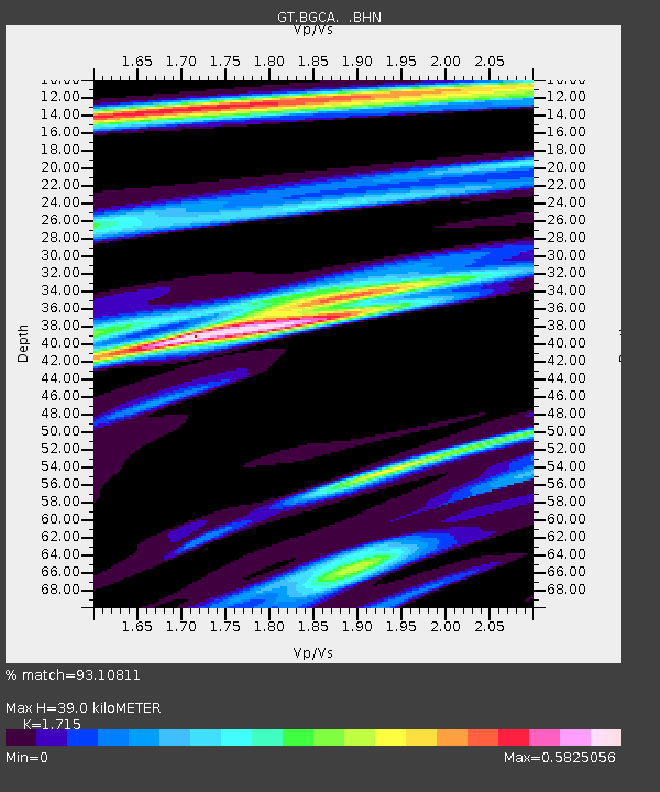
BGCA Bogoin, Central African Republic - Earthquake Result Viewer

Earthquake location: North Of Ascension Island
Earthquake latitude/longitude: -1.3/-14.3
Earthquake time(UTC): 1996/02/18 (049) 23:49:28 GMT
Earthquake Depth: 10 km
Earthquake Magnitude: 6.3 MB, 6.4 MS, 6.6 UNKNOWN, 6.5 MW
Earthquake Catalog/Contributor: WHDF/NEIC
Network: GT Global Telemetered Seismograph Network (USAF/USGS)
Station: BGCA Bogoin, Central African Republic
Lat/Lon: 5.18 N/18.42 E
Elevation: 676 m
Distance: 33.3 deg
Az: 78.625 deg
Baz: 259.761 deg
Ray Param: 0.07827749
Estimated Moho Depth: 39.0 km
Estimated Crust Vp/Vs: 1.72
Assumed Crust Vp: 6.642 km/s
Estimated Crust Vs: 3.873 km/s
Estimated Crust Poisson's Ratio: 0.24
Radial Match: 93.10811 %
Radial Bump: 290
Transverse Match: 86.417046 %
Transverse Bump: 400
SOD ConfigId: 6273
Insert Time: 2010-02-27 01:38:21.413 +0000
GWidth: 2.5
Max Bumps: 400
Tol: 0.001

Signal To Noise

ChannelStoNSTALTA
GT:BGCA: :BHN:19960218T23:55:34.902008Z28.7496661.8338749E-66.3787695E-8
GT:BGCA: :BHE:19960218T23:55:34.902008Z65.814263.5551932E-65.4018578E-8
GT:BGCA: :BHZ:19960218T23:55:34.902008Z121.5936666.157483E-65.0639834E-8
Arrivals
Ps4.6 SECOND
PpPs15 SECOND
PsPs/PpSs19 SECOND