You are here: Home > Network List > TA - USArray Transportable Network (new EarthScope stations) Stations List
> Station U49A Red Boiling Springs, TN, USA > Earthquake Result Viewer
U49A Red Boiling Springs, TN, USA - Earthquake Result Viewer
| Earthquake location: |
Hokkaido, Japan Region |
| Earthquake latitude/longitude: |
42.8/143.1 |
| Earthquake time(UTC): |
2013/02/02 (033) 14:17:35 GMT |
| Earthquake Depth: |
107 km |
| Earthquake Magnitude: |
6.4 MB, 6.9 MW, 6.9 MW |
| Earthquake Catalog/Contributor: |
WHDF/NEIC |
|
| Network: |
TA USArray Transportable Network (new EarthScope stations) |
| Station: |
U49A Red Boiling Springs, TN, USA |
| Lat/Lon: |
36.51 N/85.78 W |
| Elevation: |
234 m |
|
| Distance: |
89.4 deg |
| Az: |
37.363 deg |
| Baz: |
326.311 deg |
| Ray Param: |
0.041726876 |
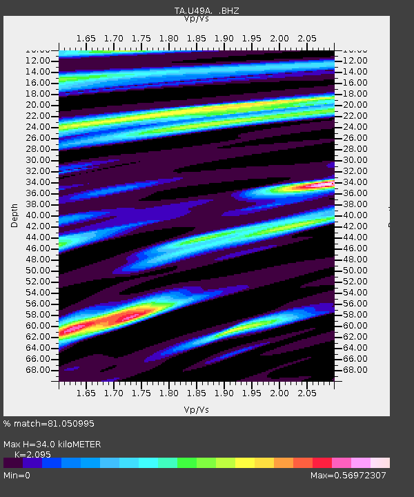
| Estimated Moho Depth: |
34.0 km |
| Estimated Crust Vp/Vs: |
2.10 |
| Assumed Crust Vp: |
6.476 km/s |
| Estimated Crust Vs: |
3.091 km/s |
| Estimated Crust Poisson's Ratio: |
0.35 |
|
| Radial Match: |
81.050995 % |
| Radial Bump: |
400 |
| Transverse Match: |
64.20622 % |
| Transverse Bump: |
400 |
| SOD ConfigId: |
494114 |
| Insert Time: |
2013-04-27 06:49:56.915 +0000 |
| GWidth: |
2.5 |
| Max Bumps: |
400 |
| Tol: |
0.001 |
|

Signal To Noise
| Channel | StoN | STA | LTA |
| TA:U49A: :BHZ:20130202T14:29:48.575007Z | 7.5562196 | 2.095596E-6 | 2.7733392E-7 |
| TA:U49A: :BHN:20130202T14:29:48.575007Z | 3.1460001 | 5.776734E-7 | 1.8362155E-7 |
| TA:U49A: :BHE:20130202T14:29:48.575007Z | 1.9261826 | 4.994254E-7 | 2.5928247E-7 |
| Arrivals |
| Ps | 5.9 SECOND |
| PpPs | 16 SECOND |
| PsPs/PpSs | 22 SECOND |


