You are here: Home > Network List > TA - USArray Transportable Network (new EarthScope stations) Stations List
> Station S49A Springfield, KY, USA > Earthquake Result Viewer
S49A Springfield, KY, USA - Earthquake Result Viewer
| Earthquake location: |
Hokkaido, Japan Region |
| Earthquake latitude/longitude: |
42.8/143.1 |
| Earthquake time(UTC): |
2013/02/02 (033) 14:17:35 GMT |
| Earthquake Depth: |
107 km |
| Earthquake Magnitude: |
6.4 MB, 6.9 MW, 6.9 MW |
| Earthquake Catalog/Contributor: |
WHDF/NEIC |
|
| Network: |
TA USArray Transportable Network (new EarthScope stations) |
| Station: |
S49A Springfield, KY, USA |
| Lat/Lon: |
37.78 N/85.29 W |
| Elevation: |
230 m |
|
| Distance: |
88.5 deg |
| Az: |
36.334 deg |
| Baz: |
326.589 deg |
| Ray Param: |
0.042278063 |
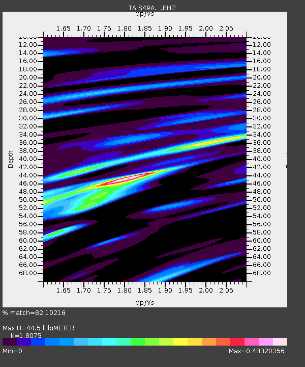
| Estimated Moho Depth: |
44.5 km |
| Estimated Crust Vp/Vs: |
1.81 |
| Assumed Crust Vp: |
6.476 km/s |
| Estimated Crust Vs: |
3.583 km/s |
| Estimated Crust Poisson's Ratio: |
0.28 |
|
| Radial Match: |
82.10216 % |
| Radial Bump: |
391 |
| Transverse Match: |
70.04357 % |
| Transverse Bump: |
400 |
| SOD ConfigId: |
494114 |
| Insert Time: |
2013-04-27 06:50:37.358 +0000 |
| GWidth: |
2.5 |
| Max Bumps: |
400 |
| Tol: |
0.001 |
|

Signal To Noise
| Channel | StoN | STA | LTA |
| TA:S49A: :BHZ:20130202T14:29:44.624995Z | 5.269828 | 2.3655127E-6 | 4.4887852E-7 |
| TA:S49A: :BHN:20130202T14:29:44.624995Z | 4.0658464 | 8.846371E-7 | 2.1757758E-7 |
| TA:S49A: :BHE:20130202T14:29:44.624995Z | 1.2951746 | 4.479189E-7 | 3.458367E-7 |
| Arrivals |
| Ps | 5.7 SECOND |
| PpPs | 19 SECOND |
| PsPs/PpSs | 25 SECOND |


