You are here: Home > Network List > TA - USArray Transportable Network (new EarthScope stations) Stations List
> Station P52A Corning, OH, USA > Earthquake Result Viewer
P52A Corning, OH, USA - Earthquake Result Viewer
| Earthquake location: |
Hokkaido, Japan Region |
| Earthquake latitude/longitude: |
42.8/143.1 |
| Earthquake time(UTC): |
2013/02/02 (033) 14:17:35 GMT |
| Earthquake Depth: |
107 km |
| Earthquake Magnitude: |
6.4 MB, 6.9 MW, 6.9 MW |
| Earthquake Catalog/Contributor: |
WHDF/NEIC |
|
| Network: |
TA USArray Transportable Network (new EarthScope stations) |
| Station: |
P52A Corning, OH, USA |
| Lat/Lon: |
39.63 N/82.13 W |
| Elevation: |
293 m |
|
| Distance: |
88.3 deg |
| Az: |
33.259 deg |
| Baz: |
328.47 deg |
| Ray Param: |
0.0424504 |
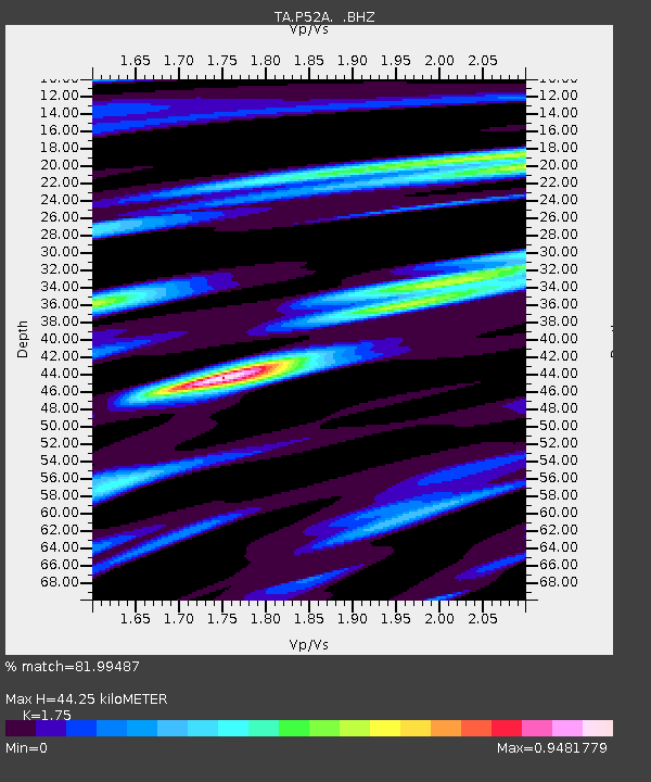
| Estimated Moho Depth: |
44.25 km |
| Estimated Crust Vp/Vs: |
1.75 |
| Assumed Crust Vp: |
6.232 km/s |
| Estimated Crust Vs: |
3.561 km/s |
| Estimated Crust Poisson's Ratio: |
0.26 |
|
| Radial Match: |
81.99487 % |
| Radial Bump: |
400 |
| Transverse Match: |
72.06252 % |
| Transverse Bump: |
400 |
| SOD ConfigId: |
494114 |
| Insert Time: |
2013-04-27 06:52:33.970 +0000 |
| GWidth: |
2.5 |
| Max Bumps: |
400 |
| Tol: |
0.001 |
|

Signal To Noise
| Channel | StoN | STA | LTA |
| TA:P52A: :BHZ:20130202T14:29:43.549983Z | 8.341306 | 2.7161389E-6 | 3.2562514E-7 |
| TA:P52A: :BHN:20130202T14:29:43.549983Z | 1.6602846 | 5.8884615E-7 | 3.546658E-7 |
| TA:P52A: :BHE:20130202T14:29:43.549983Z | 1.2126722 | 5.562187E-7 | 4.586719E-7 |
| Arrivals |
| Ps | 5.4 SECOND |
| PpPs | 19 SECOND |
| PsPs/PpSs | 25 SECOND |


