You are here: Home > Network List > TA - USArray Transportable Network (new EarthScope stations) Stations List
> Station M47A Cromwell, IN, USA > Earthquake Result Viewer
M47A Cromwell, IN, USA - Earthquake Result Viewer
| Earthquake location: |
Hokkaido, Japan Region |
| Earthquake latitude/longitude: |
42.8/143.1 |
| Earthquake time(UTC): |
2013/02/02 (033) 14:17:35 GMT |
| Earthquake Depth: |
107 km |
| Earthquake Magnitude: |
6.4 MB, 6.9 MW, 6.9 MW |
| Earthquake Catalog/Contributor: |
WHDF/NEIC |
|
| Network: |
TA USArray Transportable Network (new EarthScope stations) |
| Station: |
M47A Cromwell, IN, USA |
| Lat/Lon: |
41.36 N/85.62 W |
| Elevation: |
283 m |
|
| Distance: |
85.4 deg |
| Az: |
34.573 deg |
| Baz: |
326.284 deg |
| Ray Param: |
0.044539127 |
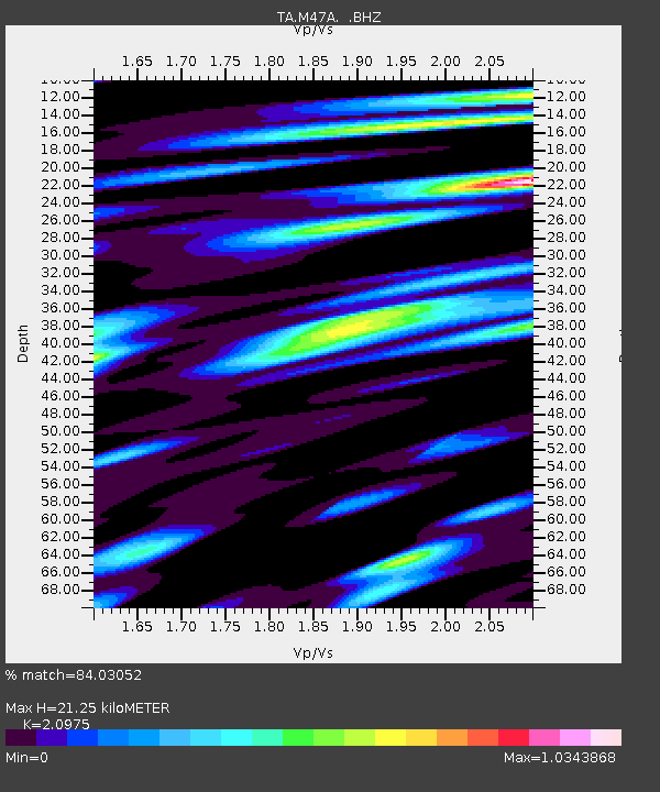
| Estimated Moho Depth: |
21.25 km |
| Estimated Crust Vp/Vs: |
2.10 |
| Assumed Crust Vp: |
6.498 km/s |
| Estimated Crust Vs: |
3.098 km/s |
| Estimated Crust Poisson's Ratio: |
0.35 |
|
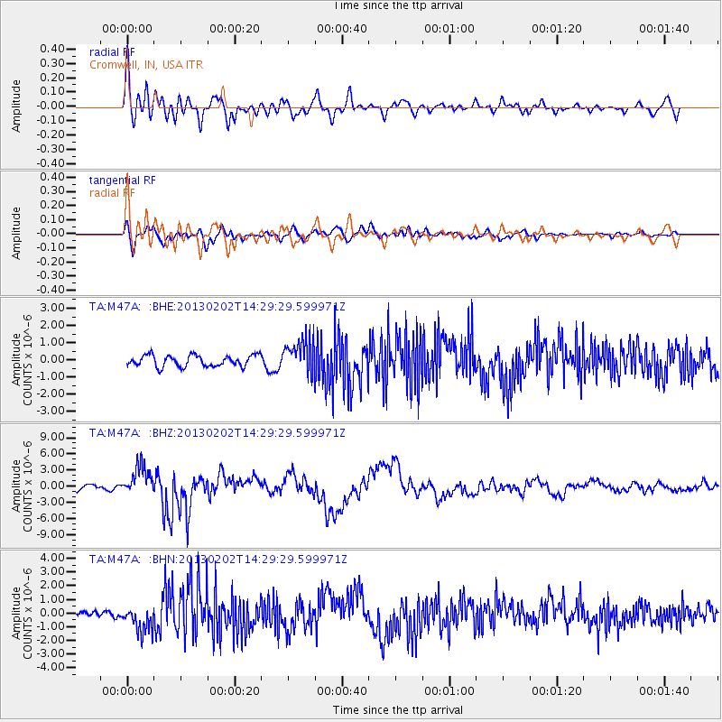
| Radial Match: |
84.03052 % |
| Radial Bump: |
400 |
| Transverse Match: |
58.686638 % |
| Transverse Bump: |
400 |
| SOD ConfigId: |
494114 |
| Insert Time: |
2013-04-27 06:53:33.949 +0000 |
| GWidth: |
2.5 |
| Max Bumps: |
400 |
| Tol: |
0.001 |
|
Signal To Noise
| Channel | StoN | STA | LTA |
| TA:M47A: :BHZ:20130202T14:29:29.599971Z | 7.8756747 | 2.7721794E-6 | 3.519926E-7 |
| TA:M47A: :BHN:20130202T14:29:29.599971Z | 2.9118416 | 9.52114E-7 | 3.2698003E-7 |
| TA:M47A: :BHE:20130202T14:29:29.599971Z | 2.9769309 | 9.828274E-7 | 3.3014786E-7 |
| Arrivals |
| Ps | 3.7 SECOND |
| PpPs | 9.9 SECOND |
| PsPs/PpSs | 14 SECOND |


