You are here: Home > Network List > GT - Global Telemetered Seismograph Network (USAF/USGS) Stations List
> Station BGCA Bogoin, Central African Republic > Earthquake Result Viewer
BGCA Bogoin, Central African Republic - Earthquake Result Viewer

| Earthquake location: |
Near Coast Of Peru |
| Earthquake latitude/longitude: |
-15.0/-75.7 |
| Earthquake time(UTC): |
1996/11/12 (317) 16:59:44 GMT |
| Earthquake Depth: |
33 km |
| Earthquake Magnitude: |
6.5 MB, 7.3 MS, 7.7 UNKNOWN, 7.7 MW |
| Earthquake Catalog/Contributor: |
WHDF/NEIC |
|
| Network: |
GT Global Telemetered Seismograph Network (USAF/USGS) |
| Station: |
BGCA Bogoin, Central African Republic |
| Lat/Lon: |
5.18 N/18.42 E |
| Elevation: |
676 m |
|
| Distance: |
95.3 deg |
| Az: |
86.067 deg |
| Baz: |
255.468 deg |
| Ray Param: |
0.040812574 |
| Estimated Moho Depth: |
49.5 km |
| Estimated Crust Vp/Vs: |
1.60 |
| Assumed Crust Vp: |
6.642 km/s |
| Estimated Crust Vs: |
4.145 km/s |
| Estimated Crust Poisson's Ratio: |
0.18 |
|
| Radial Match: |
98.75877 % |
| Radial Bump: |
351 |
| Transverse Match: |
95.70295 % |
| Transverse Bump: |
400 |
| SOD ConfigId: |
6273 |
| Insert Time: |
2010-02-27 01:38:36.951 +0000 |
| GWidth: |
2.5 |
| Max Bumps: |
400 |
| Tol: |
0.001 |
|
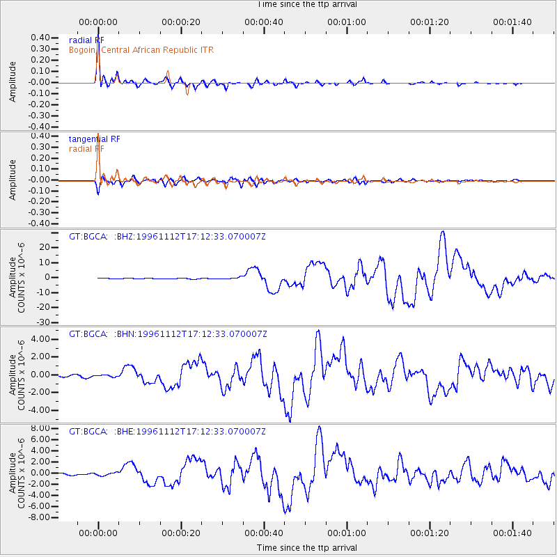
Signal To Noise
| Channel | StoN | STA | LTA |
| GT:BGCA: :BHN:19961112T17:12:33.070007Z | 1.2612501 | 1.0069556E-7 | 7.9837896E-8 |
| GT:BGCA: :BHE:19961112T17:12:33.070007Z | 1.9778333 | 2.652767E-7 | 1.341249E-7 |
| GT:BGCA: :BHZ:19961112T17:12:33.070007Z | 3.2677243 | 7.138905E-7 | 2.1846716E-7 |
| Arrivals |
| Ps | 4.6 SECOND |
| PpPs | 19 SECOND |
| PsPs/PpSs | 24 SECOND |


