You are here: Home > Network List > TA - USArray Transportable Network (new EarthScope stations) Stations List
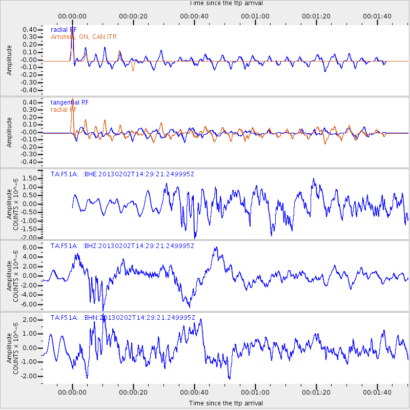
> Station F51A Arnstein, ON, CAN > Earthquake Result Viewer
F51A Arnstein, ON, CAN - Earthquake Result Viewer
| Earthquake location: |
Hokkaido, Japan Region |
| Earthquake latitude/longitude: |
42.8/143.1 |
| Earthquake time(UTC): |
2013/02/02 (033) 14:17:35 GMT |
| Earthquake Depth: |
107 km |
| Earthquake Magnitude: |
6.4 MB, 6.9 MW, 6.9 MW |
| Earthquake Catalog/Contributor: |
WHDF/NEIC |
|
| Network: |
TA USArray Transportable Network (new EarthScope stations) |
| Station: |
F51A Arnstein, ON, CAN |
| Lat/Lon: |
45.93 N/79.92 W |
| Elevation: |
239 m |
|
| Distance: |
83.8 deg |
| Az: |
28.614 deg |
| Baz: |
329.652 deg |
| Ray Param: |
0.045726478 |
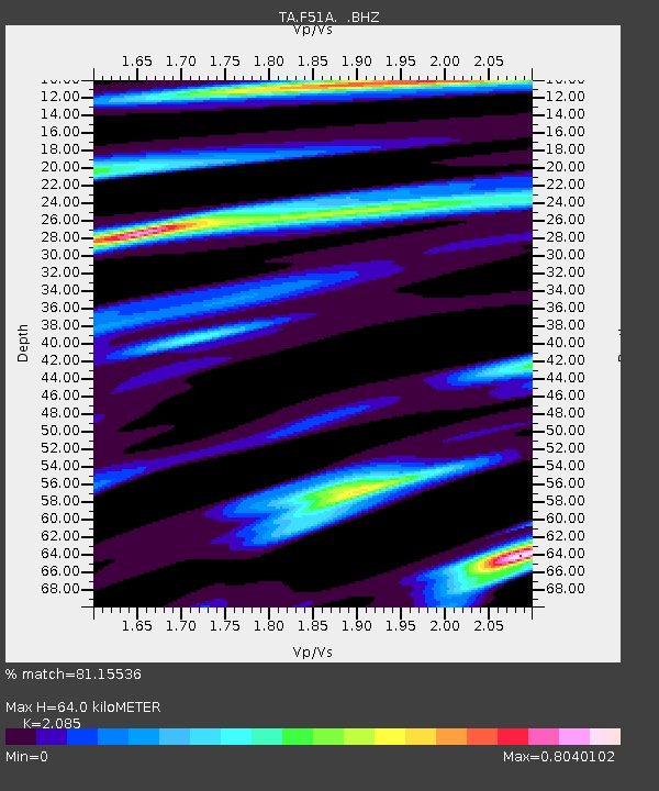
| Estimated Moho Depth: |
64.0 km |
| Estimated Crust Vp/Vs: |
2.09 |
| Assumed Crust Vp: |
6.577 km/s |
| Estimated Crust Vs: |
3.154 km/s |
| Estimated Crust Poisson's Ratio: |
0.35 |
|
| Radial Match: |
81.15536 % |
| Radial Bump: |
400 |
| Transverse Match: |
54.297764 % |
| Transverse Bump: |
400 |
| SOD ConfigId: |
494114 |
| Insert Time: |
2013-04-27 06:56:31.719 +0000 |
| GWidth: |
2.5 |
| Max Bumps: |
400 |
| Tol: |
0.001 |
|
Signal To Noise
| Channel | StoN | STA | LTA |
| TA:F51A: :BHZ:20130202T14:29:21.249995Z | 6.3761067 | 2.7639303E-6 | 4.3348243E-7 |
| TA:F51A: :BHN:20130202T14:29:21.249995Z | 1.7180132 | 9.629049E-7 | 5.604759E-7 |
| TA:F51A: :BHE:20130202T14:29:21.249995Z | 2.1621215 | 6.862241E-7 | 3.1738463E-7 |
| Arrivals |
| Ps | 11 SECOND |
| PpPs | 29 SECOND |
| PsPs/PpSs | 40 SECOND |


