You are here: Home > Network List > TA - USArray Transportable Network (new EarthScope stations) Stations List
> Station I45A Fountain, MI, USA > Earthquake Result Viewer
I45A Fountain, MI, USA - Earthquake Result Viewer
| Earthquake location: |
Hokkaido, Japan Region |
| Earthquake latitude/longitude: |
42.8/143.1 |
| Earthquake time(UTC): |
2013/02/02 (033) 14:17:35 GMT |
| Earthquake Depth: |
107 km |
| Earthquake Magnitude: |
6.4 MB, 6.9 MW, 6.9 MW |
| Earthquake Catalog/Contributor: |
WHDF/NEIC |
|
| Network: |
TA USArray Transportable Network (new EarthScope stations) |
| Station: |
I45A Fountain, MI, USA |
| Lat/Lon: |
44.04 N/86.23 W |
| Elevation: |
215 m |
|
| Distance: |
83.0 deg |
| Az: |
33.447 deg |
| Baz: |
325.756 deg |
| Ray Param: |
0.04629013 |
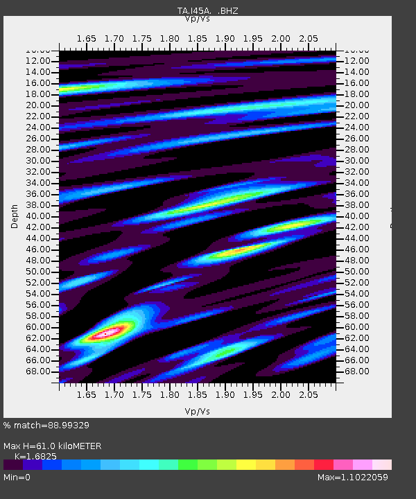
| Estimated Moho Depth: |
61.0 km |
| Estimated Crust Vp/Vs: |
1.68 |
| Assumed Crust Vp: |
6.53 km/s |
| Estimated Crust Vs: |
3.881 km/s |
| Estimated Crust Poisson's Ratio: |
0.23 |
|
| Radial Match: |
88.99329 % |
| Radial Bump: |
400 |
| Transverse Match: |
67.3841 % |
| Transverse Bump: |
400 |
| SOD ConfigId: |
494114 |
| Insert Time: |
2013-04-27 06:56:32.473 +0000 |
| GWidth: |
2.5 |
| Max Bumps: |
400 |
| Tol: |
0.001 |
|
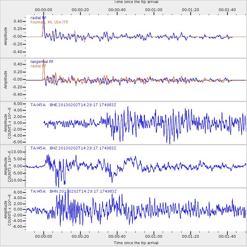
Signal To Noise
| Channel | StoN | STA | LTA |
| TA:I45A: :BHZ:20130202T14:29:17.174983Z | 6.288443 | 3.6097185E-6 | 5.740242E-7 |
| TA:I45A: :BHN:20130202T14:29:17.174983Z | 2.484171 | 1.3342766E-6 | 5.371114E-7 |
| TA:I45A: :BHE:20130202T14:29:17.174983Z | 1.8048147 | 1.053659E-6 | 5.838046E-7 |
| Arrivals |
| Ps | 6.6 SECOND |
| PpPs | 24 SECOND |
| PsPs/PpSs | 31 SECOND |


