You are here: Home > Network List > TA - USArray Transportable Network (new EarthScope stations) Stations List
> Station I51A Listowel, ON, CAN > Earthquake Result Viewer
I51A Listowel, ON, CAN - Earthquake Result Viewer
| Earthquake location: |
Hokkaido, Japan Region |
| Earthquake latitude/longitude: |
42.8/143.1 |
| Earthquake time(UTC): |
2013/02/02 (033) 14:17:35 GMT |
| Earthquake Depth: |
107 km |
| Earthquake Magnitude: |
6.4 MB, 6.9 MW, 6.9 MW |
| Earthquake Catalog/Contributor: |
WHDF/NEIC |
|
| Network: |
TA USArray Transportable Network (new EarthScope stations) |
| Station: |
I51A Listowel, ON, CAN |
| Lat/Lon: |
43.80 N/81.02 W |
| Elevation: |
376 m |
|
| Distance: |
85.2 deg |
| Az: |
30.384 deg |
| Baz: |
329.043 deg |
| Ray Param: |
0.044714615 |
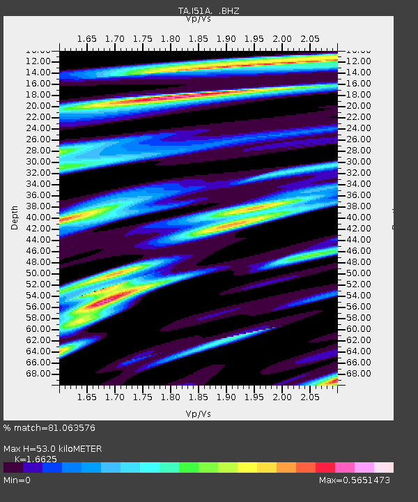
| Estimated Moho Depth: |
53.0 km |
| Estimated Crust Vp/Vs: |
1.66 |
| Assumed Crust Vp: |
6.53 km/s |
| Estimated Crust Vs: |
3.928 km/s |
| Estimated Crust Poisson's Ratio: |
0.22 |
|
| Radial Match: |
81.063576 % |
| Radial Bump: |
400 |
| Transverse Match: |
64.16298 % |
| Transverse Bump: |
400 |
| SOD ConfigId: |
494114 |
| Insert Time: |
2013-04-27 06:58:15.580 +0000 |
| GWidth: |
2.5 |
| Max Bumps: |
400 |
| Tol: |
0.001 |
|
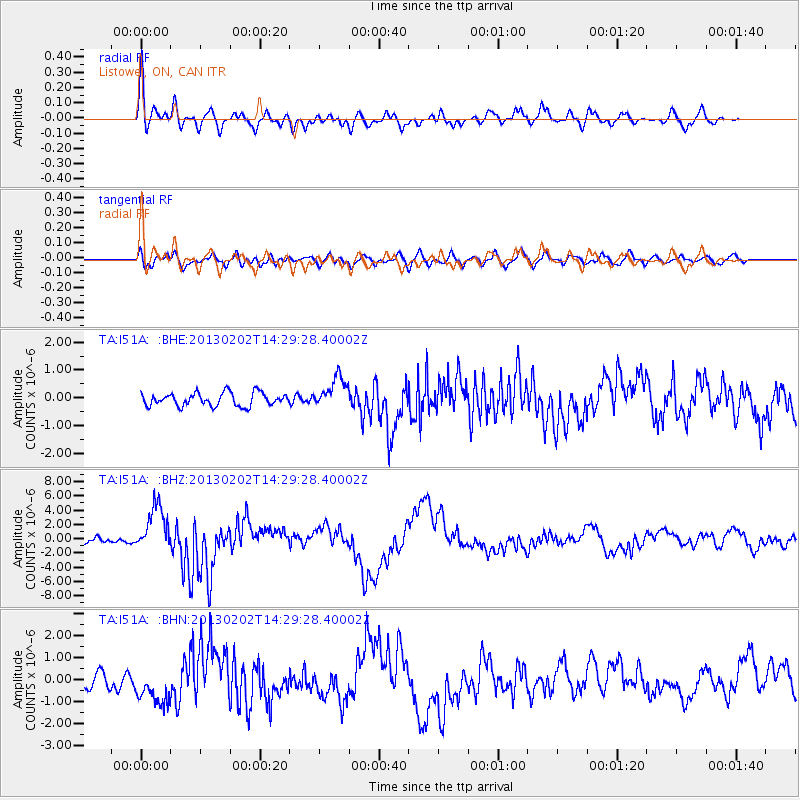
Signal To Noise
| Channel | StoN | STA | LTA |
| TA:I51A: :BHZ:20130202T14:29:28.40002Z | 7.8336563 | 3.254398E-6 | 4.1543797E-7 |
| TA:I51A: :BHN:20130202T14:29:28.40002Z | 2.0020006 | 8.463643E-7 | 4.2275926E-7 |
| TA:I51A: :BHE:20130202T14:29:28.40002Z | 2.3722262 | 5.60401E-7 | 2.3623424E-7 |
| Arrivals |
| Ps | 5.5 SECOND |
| PpPs | 21 SECOND |
| PsPs/PpSs | 27 SECOND |


