You are here: Home > Network List > TA - USArray Transportable Network (new EarthScope stations) Stations List
> Station R53A Hurricane, WV, USA > Earthquake Result Viewer
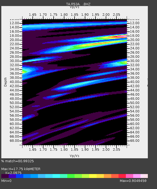
R53A Hurricane, WV, USA - Earthquake Result Viewer
| Earthquake location: |
Hokkaido, Japan Region |
| Earthquake latitude/longitude: |
42.8/143.1 |
| Earthquake time(UTC): |
2013/02/02 (033) 14:17:35 GMT |
| Earthquake Depth: |
107 km |
| Earthquake Magnitude: |
6.4 MB, 6.9 MW, 6.9 MW |
| Earthquake Catalog/Contributor: |
WHDF/NEIC |
|
| Network: |
TA USArray Transportable Network (new EarthScope stations) |
| Station: |
R53A Hurricane, WV, USA |
| Lat/Lon: |
38.33 N/81.95 W |
| Elevation: |
294 m |
|
| Distance: |
89.5 deg |
| Az: |
33.818 deg |
| Baz: |
328.594 deg |
| Ray Param: |
0.04171898 |
| Estimated Moho Depth: |
17.75 km |
| Estimated Crust Vp/Vs: |
2.10 |
| Assumed Crust Vp: |
6.207 km/s |
| Estimated Crust Vs: |
2.959 km/s |
| Estimated Crust Poisson's Ratio: |
0.35 |
|
| Radial Match: |
80.99325 % |
| Radial Bump: |
400 |
| Transverse Match: |
62.350803 % |
| Transverse Bump: |
400 |
| SOD ConfigId: |
494114 |
| Insert Time: |
2013-04-27 06:59:36.734 +0000 |
| GWidth: |
2.5 |
| Max Bumps: |
400 |
| Tol: |
0.001 |
|

Signal To Noise
| Channel | StoN | STA | LTA |
| TA:R53A: :BHZ:20130202T14:29:49.075007Z | 4.8007727 | 2.2948286E-6 | 4.7801234E-7 |
| TA:R53A: :BHN:20130202T14:29:49.075007Z | 1.776371 | 6.269091E-7 | 3.5291566E-7 |
| TA:R53A: :BHE:20130202T14:29:49.075007Z | 1.2054464 | 5.9633214E-7 | 4.946982E-7 |
| Arrivals |
| Ps | 3.2 SECOND |
| PpPs | 8.7 SECOND |
| PsPs/PpSs | 12 SECOND |


