You are here: Home > Network List > TA - USArray Transportable Network (new EarthScope stations) Stations List
> Station M52A Chesterland, OH, USA > Earthquake Result Viewer
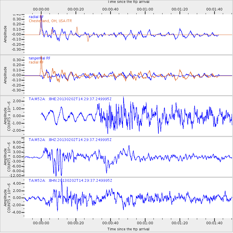
M52A Chesterland, OH, USA - Earthquake Result Viewer
*The percent match for this event was below the threshold and hence no stack was calculated.
| Earthquake location: |
Hokkaido, Japan Region |
| Earthquake latitude/longitude: |
42.8/143.1 |
| Earthquake time(UTC): |
2013/02/02 (033) 14:17:35 GMT |
| Earthquake Depth: |
107 km |
| Earthquake Magnitude: |
6.4 MB, 6.9 MW, 6.9 MW |
| Earthquake Catalog/Contributor: |
WHDF/NEIC |
|
| Network: |
TA USArray Transportable Network (new EarthScope stations) |
| Station: |
M52A Chesterland, OH, USA |
| Lat/Lon: |
41.54 N/81.36 W |
| Elevation: |
382 m |
|
| Distance: |
87.0 deg |
| Az: |
31.763 deg |
| Baz: |
328.912 deg |
| Ray Param: |
$rayparam |
*The percent match for this event was below the threshold and hence was not used in the summary stack. |
|
| Radial Match: |
79.31626 % |
| Radial Bump: |
400 |
| Transverse Match: |
68.34957 % |
| Transverse Bump: |
400 |
| SOD ConfigId: |
494114 |
| Insert Time: |
2013-04-27 06:59:52.396 +0000 |
| GWidth: |
2.5 |
| Max Bumps: |
400 |
| Tol: |
0.001 |
|
Signal To Noise
| Channel | StoN | STA | LTA |
| TA:M52A: :BHZ:20130202T14:29:37.249995Z | 7.1609244 | 2.8983072E-6 | 4.0473924E-7 |
| TA:M52A: :BHN:20130202T14:29:37.249995Z | 2.1205742 | 1.0132812E-6 | 4.778334E-7 |
| TA:M52A: :BHE:20130202T14:29:37.249995Z | 1.4345503 | 7.3720884E-7 | 5.1389543E-7 |
| Arrivals |
| Ps | |
| PpPs | |
| PsPs/PpSs | |


