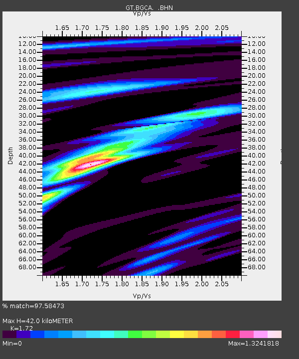
BGCA Bogoin, Central African Republic - Earthquake Result Viewer

Earthquake location: Hindu Kush Region, Afghanistan
Earthquake latitude/longitude: 36.4/70.9
Earthquake time(UTC): 1997/05/13 (133) 14:13:45 GMT
Earthquake Depth: 196 km
Earthquake Magnitude: 6.1 MB, 6.5 UNKNOWN, 6.4 MW
Earthquake Catalog/Contributor: WHDF/NEIC
Network: GT Global Telemetered Seismograph Network (USAF/USGS)
Station: BGCA Bogoin, Central African Republic
Lat/Lon: 5.18 N/18.42 E
Elevation: 676 m
Distance: 57.2 deg
Az: 250.116 deg
Baz: 49.61 deg
Ray Param: 0.06300909
Estimated Moho Depth: 42.0 km
Estimated Crust Vp/Vs: 1.72
Assumed Crust Vp: 6.642 km/s
Estimated Crust Vs: 3.862 km/s
Estimated Crust Poisson's Ratio: 0.24
Radial Match: 97.58473 %
Radial Bump: 283
Transverse Match: 88.96961 %
Transverse Bump: 400
SOD ConfigId: 6273
Insert Time: 2010-02-27 01:38:52.841 +0000
GWidth: 2.5
Max Bumps: 400
Tol: 0.001

Signal To Noise

ChannelStoNSTALTA
GT:BGCA: :BHN:19970513T14:22:41.454028Z78.193932.9515695E-63.7746783E-8
GT:BGCA: :BHE:19970513T14:22:41.454028Z26.2265472.0625541E-67.864375E-8
GT:BGCA: :BHZ:19970513T14:22:41.454028Z87.017647.0511555E-68.103134E-8
Arrivals
Ps4.8 SECOND
PpPs16 SECOND
PsPs/PpSs21 SECOND