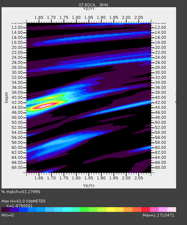
BGCA Bogoin, Central African Republic - Earthquake Result Viewer

Earthquake location: South Sandwich Islands Region
Earthquake latitude/longitude: -57.8/-25.5
Earthquake time(UTC): 1997/06/02 (153) 21:24:38 GMT
Earthquake Depth: 33 km
Earthquake Magnitude: 5.9 MB, 5.8 MS, 6.1 UNKNOWN, 6.1 MW
Earthquake Catalog/Contributor: WHDF/NEIC
Network: GT Global Telemetered Seismograph Network (USAF/USGS)
Station: BGCA Bogoin, Central African Republic
Lat/Lon: 5.18 N/18.42 E
Elevation: 676 m
Distance: 72.0 deg
Az: 46.552 deg
Baz: 202.989 deg
Ray Param: 0.05389874
Estimated Moho Depth: 43.0 km
Estimated Crust Vp/Vs: 1.68
Assumed Crust Vp: 6.642 km/s
Estimated Crust Vs: 3.965 km/s
Estimated Crust Poisson's Ratio: 0.22
Radial Match: 83.27995 %
Radial Bump: 400
Transverse Match: 63.20949 %
Transverse Bump: 400
SOD ConfigId: 6273
Insert Time: 2010-02-27 01:39:00.213 +0000
GWidth: 2.5
Max Bumps: 400
Tol: 0.001

Signal To Noise

ChannelStoNSTALTA
GT:BGCA: :BHN:19970602T21:35:27.93302Z3.35726144.5734643E-71.3622605E-7
GT:BGCA: :BHE:19970602T21:35:27.93302Z1.71066451.3092895E-77.65369E-8
GT:BGCA: :BHZ:19970602T21:35:27.93302Z4.73964458.324697E-71.756397E-7
Arrivals
Ps4.5 SECOND
PpPs17 SECOND
PsPs/PpSs21 SECOND