You are here: Home > Network List > CI - Caltech Regional Seismic Network Stations List
> Station SWS Sam W. Stewart, Westmorland, CA, USA > Earthquake Result Viewer
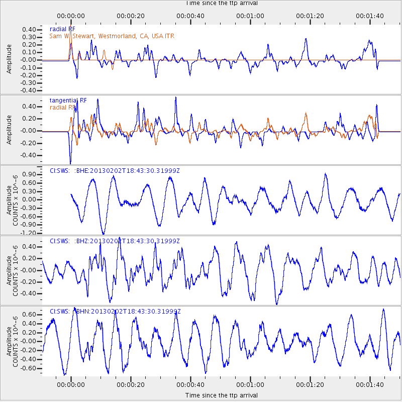
SWS Sam W. Stewart, Westmorland, CA, USA - Earthquake Result Viewer
*The percent match for this event was below the threshold and hence no stack was calculated.
| Earthquake location: |
Southeast Of Honshu, Japan |
| Earthquake latitude/longitude: |
29.3/142.0 |
| Earthquake time(UTC): |
2013/02/02 (033) 18:31:36 GMT |
| Earthquake Depth: |
41 km |
| Earthquake Magnitude: |
5.5 MB, 5.4 MS |
| Earthquake Catalog/Contributor: |
WHDF/NEIC |
|
| Network: |
CI Caltech Regional Seismic Network |
| Station: |
SWS Sam W. Stewart, Westmorland, CA, USA |
| Lat/Lon: |
32.94 N/115.80 W |
| Elevation: |
140 m |
|
| Distance: |
83.8 deg |
| Az: |
55.766 deg |
| Baz: |
300.855 deg |
| Ray Param: |
$rayparam |
*The percent match for this event was below the threshold and hence was not used in the summary stack. |
|
| Radial Match: |
42.91409 % |
| Radial Bump: |
320 |
| Transverse Match: |
48.659683 % |
| Transverse Bump: |
282 |
| SOD ConfigId: |
494114 |
| Insert Time: |
2013-04-27 07:07:54.678 +0000 |
| GWidth: |
2.5 |
| Max Bumps: |
400 |
| Tol: |
0.001 |
|
Signal To Noise
| Channel | StoN | STA | LTA |
| CI:SWS: :BHZ:20130202T18:43:30.31999Z | 0.6304675 | 1.1671327E-7 | 1.8512179E-7 |
| CI:SWS: :BHN:20130202T18:43:30.31999Z | 1.4854684 | 4.4068628E-7 | 2.9666487E-7 |
| CI:SWS: :BHE:20130202T18:43:30.31999Z | 1.3617345 | 6.6247424E-7 | 4.864929E-7 |
| Arrivals |
| Ps | |
| PpPs | |
| PsPs/PpSs | |


