You are here: Home > Network List > GT - Global Telemetered Seismograph Network (USAF/USGS) Stations List
> Station BGCA Bogoin, Central African Republic > Earthquake Result Viewer
BGCA Bogoin, Central African Republic - Earthquake Result Viewer

| Earthquake location: |
Ascension Island Region |
| Earthquake latitude/longitude: |
-11.6/-13.9 |
| Earthquake time(UTC): |
1998/06/18 (169) 04:17:54 GMT |
| Earthquake Depth: |
10 km |
| Earthquake Magnitude: |
6.1 MS, 5.4 MB, 6.2 UNKNOWN |
| Earthquake Catalog/Contributor: |
WHDF/NEIC |
|
| Network: |
GT Global Telemetered Seismograph Network (USAF/USGS) |
| Station: |
BGCA Bogoin, Central African Republic |
| Lat/Lon: |
5.18 N/18.42 E |
| Elevation: |
676 m |
|
| Distance: |
36.2 deg |
| Az: |
64.359 deg |
| Baz: |
242.5 deg |
| Ray Param: |
0.07680927 |
| Estimated Moho Depth: |
33.5 km |
| Estimated Crust Vp/Vs: |
1.86 |
| Assumed Crust Vp: |
6.642 km/s |
| Estimated Crust Vs: |
3.581 km/s |
| Estimated Crust Poisson's Ratio: |
0.30 |
|
| Radial Match: |
93.57124 % |
| Radial Bump: |
350 |
| Transverse Match: |
90.75594 % |
| Transverse Bump: |
400 |
| SOD ConfigId: |
4480 |
| Insert Time: |
2010-02-27 01:39:18.251 +0000 |
| GWidth: |
2.5 |
| Max Bumps: |
400 |
| Tol: |
0.001 |
|
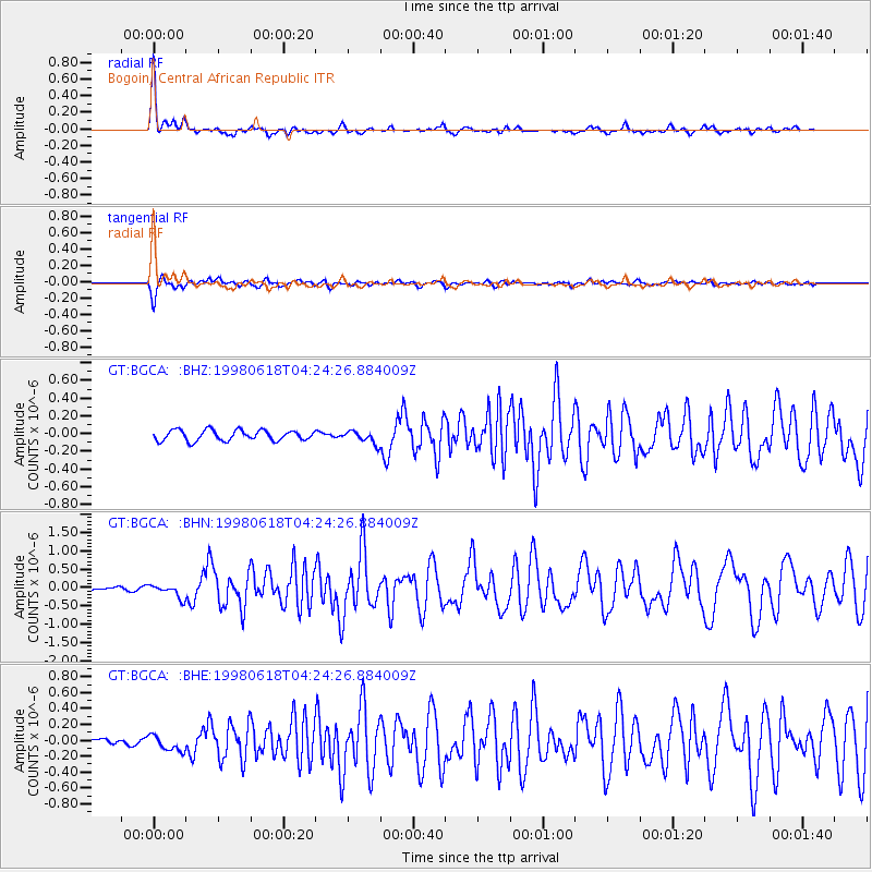
Signal To Noise
| Channel | StoN | STA | LTA |
| GT:BGCA: :BHN:19980618T04:24:26.884009Z | 3.411557 | 1.8489268E-7 | 5.419598E-8 |
| GT:BGCA: :BHE:19980618T04:24:26.884009Z | 2.7532687 | 9.8251455E-8 | 3.5685385E-8 |
| GT:BGCA: :BHZ:19980618T04:24:26.884009Z | 1.1879007 | 7.0197224E-8 | 5.9093516E-8 |
| Arrivals |
| Ps | 4.7 SECOND |
| PpPs | 13 SECOND |
| PsPs/PpSs | 18 SECOND |


