You are here: Home > Network List > TA - USArray Transportable Network (new EarthScope stations) Stations List
> Station E46A Sault Ste Marie, MI, USA > Earthquake Result Viewer
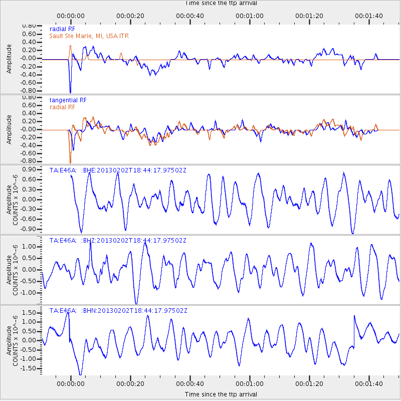
E46A Sault Ste Marie, MI, USA - Earthquake Result Viewer
*The percent match for this event was below the threshold and hence no stack was calculated.
| Earthquake location: |
Southeast Of Honshu, Japan |
| Earthquake latitude/longitude: |
29.3/142.0 |
| Earthquake time(UTC): |
2013/02/02 (033) 18:31:36 GMT |
| Earthquake Depth: |
41 km |
| Earthquake Magnitude: |
5.5 MB, 5.4 MS |
| Earthquake Catalog/Contributor: |
WHDF/NEIC |
|
| Network: |
TA USArray Transportable Network (new EarthScope stations) |
| Station: |
E46A Sault Ste Marie, MI, USA |
| Lat/Lon: |
46.37 N/84.31 W |
| Elevation: |
269 m |
|
| Distance: |
93.8 deg |
| Az: |
30.113 deg |
| Baz: |
320.756 deg |
| Ray Param: |
$rayparam |
*The percent match for this event was below the threshold and hence was not used in the summary stack. |
|
| Radial Match: |
42.038292 % |
| Radial Bump: |
400 |
| Transverse Match: |
49.670296 % |
| Transverse Bump: |
400 |
| SOD ConfigId: |
494114 |
| Insert Time: |
2013-04-27 07:11:35.630 +0000 |
| GWidth: |
2.5 |
| Max Bumps: |
400 |
| Tol: |
0.001 |
|
Signal To Noise
| Channel | StoN | STA | LTA |
| TA:E46A: :BHZ:20130202T18:44:17.97502Z | 0.9324336 | 3.456851E-7 | 3.7073426E-7 |
| TA:E46A: :BHN:20130202T18:44:17.97502Z | 3.8205705 | 1.2630737E-6 | 3.305982E-7 |
| TA:E46A: :BHE:20130202T18:44:17.97502Z | 0.71408635 | 3.0845285E-7 | 4.3195456E-7 |
| Arrivals |
| Ps | |
| PpPs | |
| PsPs/PpSs | |


