You are here: Home > Network List > TA - USArray Transportable Network (new EarthScope stations) Stations List
> Station 109C Camp Elliot, Mirimar, CA, USA > Earthquake Result Viewer
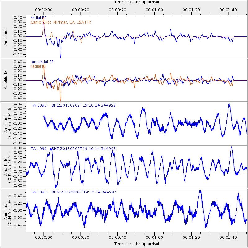
109C Camp Elliot, Mirimar, CA, USA - Earthquake Result Viewer
*The percent match for this event was below the threshold and hence no stack was calculated.
| Earthquake location: |
Santa Cruz Islands |
| Earthquake latitude/longitude: |
-10.9/165.3 |
| Earthquake time(UTC): |
2013/02/02 (033) 18:58:06 GMT |
| Earthquake Depth: |
6.0 km |
| Earthquake Magnitude: |
5.7 MS, 5.4 MB, 6.0 MW, 5.9 MW |
| Earthquake Catalog/Contributor: |
WHDF/NEIC |
|
| Network: |
TA USArray Transportable Network (new EarthScope stations) |
| Station: |
109C Camp Elliot, Mirimar, CA, USA |
| Lat/Lon: |
32.89 N/117.11 W |
| Elevation: |
150 m |
|
| Distance: |
85.6 deg |
| Az: |
55.504 deg |
| Baz: |
254.183 deg |
| Ray Param: |
$rayparam |
*The percent match for this event was below the threshold and hence was not used in the summary stack. |
|
| Radial Match: |
77.688416 % |
| Radial Bump: |
400 |
| Transverse Match: |
57.454002 % |
| Transverse Bump: |
400 |
| SOD ConfigId: |
494114 |
| Insert Time: |
2013-04-27 07:17:40.991 +0000 |
| GWidth: |
2.5 |
| Max Bumps: |
400 |
| Tol: |
0.001 |
|
Signal To Noise
| Channel | StoN | STA | LTA |
| TA:109C: :BHZ:20130202T19:10:14.34499Z | 1.8939116 | 4.887646E-7 | 2.5807148E-7 |
| TA:109C: :BHN:20130202T19:10:14.34499Z | 1.416034 | 1.5502303E-7 | 1.0947691E-7 |
| TA:109C: :BHE:20130202T19:10:14.34499Z | 1.8579165 | 2.9685887E-7 | 1.5978053E-7 |
| Arrivals |
| Ps | |
| PpPs | |
| PsPs/PpSs | |


