You are here: Home > Network List > AU - Australian Seismological Centre Stations List
> Station KMBL Kambalda, Western Australia > Earthquake Result Viewer
KMBL Kambalda, Western Australia - Earthquake Result Viewer
| Earthquake location: |
Santa Cruz Islands |
| Earthquake latitude/longitude: |
-10.9/165.2 |
| Earthquake time(UTC): |
2013/02/06 (037) 00:07:22 GMT |
| Earthquake Depth: |
11 km |
| Earthquake Magnitude: |
5.6 MB, 6.1 MS, 6.0 MW, 6.0 MW |
| Earthquake Catalog/Contributor: |
WHDF/NEIC |
|
| Network: |
AU Australian Seismological Centre |
| Station: |
KMBL Kambalda, Western Australia |
| Lat/Lon: |
31.37 S/121.88 E |
| Elevation: |
370 m |
|
| Distance: |
44.9 deg |
| Az: |
236.257 deg |
| Baz: |
72.729 deg |
| Ray Param: |
0.071604624 |
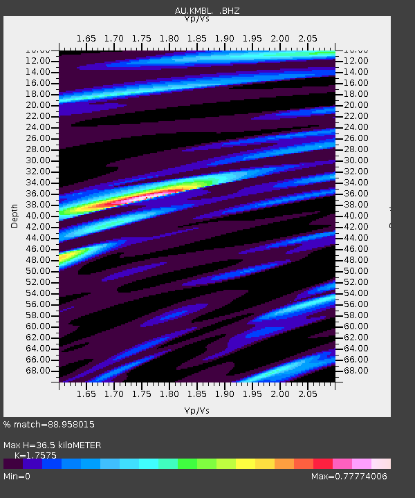
| Estimated Moho Depth: |
36.5 km |
| Estimated Crust Vp/Vs: |
1.76 |
| Assumed Crust Vp: |
6.459 km/s |
| Estimated Crust Vs: |
3.675 km/s |
| Estimated Crust Poisson's Ratio: |
0.26 |
|
| Radial Match: |
88.958015 % |
| Radial Bump: |
359 |
| Transverse Match: |
64.05666 % |
| Transverse Bump: |
400 |
| SOD ConfigId: |
494114 |
| Insert Time: |
2013-05-01 04:10:45.348 +0000 |
| GWidth: |
2.5 |
| Max Bumps: |
400 |
| Tol: |
0.001 |
|

Signal To Noise
| Channel | StoN | STA | LTA |
| AU:KMBL: :BHZ:20130206T00:15:06.020013Z | 7.106734 | 1.54673E-6 | 2.1764289E-7 |
| AU:KMBL: :BHN:20130206T00:15:06.020013Z | 1.8975517 | 3.1082175E-7 | 1.6380147E-7 |
| AU:KMBL: :BHE:20130206T00:15:06.020013Z | 4.351028 | 7.235322E-7 | 1.6628994E-7 |
| Arrivals |
| Ps | 4.6 SECOND |
| PpPs | 15 SECOND |
| PsPs/PpSs | 19 SECOND |


