You are here: Home > Network List > AU - Australian Seismological Centre Stations List
> Station WB2 Warramunga Array, NT > Earthquake Result Viewer
WB2 Warramunga Array, NT - Earthquake Result Viewer
| Earthquake location: |
Santa Cruz Islands |
| Earthquake latitude/longitude: |
-10.9/165.2 |
| Earthquake time(UTC): |
2013/02/06 (037) 00:07:22 GMT |
| Earthquake Depth: |
11 km |
| Earthquake Magnitude: |
5.6 MB, 6.1 MS, 6.0 MW, 6.0 MW |
| Earthquake Catalog/Contributor: |
WHDF/NEIC |
|
| Network: |
AU Australian Seismological Centre |
| Station: |
WB2 Warramunga Array, NT |
| Lat/Lon: |
19.94 S/134.35 E |
| Elevation: |
425 m |
|
| Distance: |
31.1 deg |
| Az: |
249.367 deg |
| Baz: |
77.738 deg |
| Ray Param: |
0.07916298 |
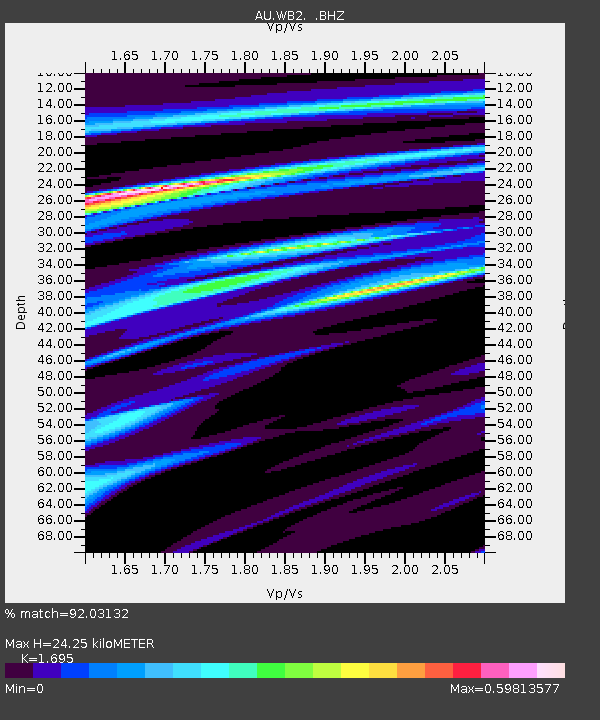
| Estimated Moho Depth: |
24.25 km |
| Estimated Crust Vp/Vs: |
1.70 |
| Assumed Crust Vp: |
6.642 km/s |
| Estimated Crust Vs: |
3.919 km/s |
| Estimated Crust Poisson's Ratio: |
0.23 |
|
| Radial Match: |
92.03132 % |
| Radial Bump: |
247 |
| Transverse Match: |
79.73071 % |
| Transverse Bump: |
400 |
| SOD ConfigId: |
494114 |
| Insert Time: |
2013-05-01 04:10:54.321 +0000 |
| GWidth: |
2.5 |
| Max Bumps: |
400 |
| Tol: |
0.001 |
|

Signal To Noise
| Channel | StoN | STA | LTA |
| AU:WB2: :BHZ:20130206T00:13:09.475Z | 14.162089 | 1.1567708E-6 | 8.16808E-8 |
| AU:WB2: :BHN:20130206T00:13:09.475Z | 3.462884 | 3.4679556E-7 | 1.0014646E-7 |
| AU:WB2: :BHE:20130206T00:13:09.475Z | 8.383232 | 8.125178E-7 | 9.692178E-8 |
| Arrivals |
| Ps | 2.8 SECOND |
| PpPs | 9.0 SECOND |
| PsPs/PpSs | 12 SECOND |


