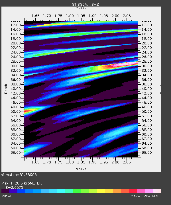
BGCA Bogoin, Central African Republic - Earthquake Result Viewer

Earthquake location: Afghanistan-Tajikistan Bord Reg.
Earthquake latitude/longitude: 36.5/71.0
Earthquake time(UTC): 1998/12/11 (345) 20:16:24 GMT
Earthquake Depth: 223 km
Earthquake Magnitude: 5.7 UNKNOWN, 5.0 MB, 5.6 MW
Earthquake Catalog/Contributor: WHDF/NEIC
Network: GT Global Telemetered Seismograph Network (USAF/USGS)
Station: BGCA Bogoin, Central African Republic
Lat/Lon: 5.18 N/18.42 E
Elevation: 676 m
Distance: 57.3 deg
Az: 250.113 deg
Baz: 49.52 deg
Ray Param: 0.06284613
Estimated Moho Depth: 28.5 km
Estimated Crust Vp/Vs: 2.06
Assumed Crust Vp: 6.642 km/s
Estimated Crust Vs: 3.228 km/s
Estimated Crust Poisson's Ratio: 0.35
Radial Match: 81.55098 %
Radial Bump: 400
Transverse Match: 63.00105 %
Transverse Bump: 400
SOD ConfigId: 4480
Insert Time: 2010-02-27 01:39:43.599 +0000
GWidth: 2.5
Max Bumps: 400
Tol: 0.001

Signal To Noise

ChannelStoNSTALTA
GT:BGCA: :BHZ:19981211T20:25:17.567993Z4.6463213.4594905E-77.445655E-8
GT:BGCA: :BHN:19981211T20:25:17.567993Z3.67378691.593685E-74.33799E-8
GT:BGCA: :BHE:19981211T20:25:17.567993Z3.48673341.5491027E-74.442848E-8
Arrivals
Ps4.7 SECOND
PpPs13 SECOND
PsPs/PpSs17 SECOND