You are here: Home > Network List > AZ - ANZA Regional Network Stations List
> Station SCI2 San Clemente Island, CA, USA > Earthquake Result Viewer
SCI2 San Clemente Island, CA, USA - Earthquake Result Viewer
| Earthquake location: |
Santa Cruz Islands |
| Earthquake latitude/longitude: |
-10.9/165.2 |
| Earthquake time(UTC): |
2013/02/06 (037) 00:07:22 GMT |
| Earthquake Depth: |
11 km |
| Earthquake Magnitude: |
5.6 MB, 6.1 MS, 6.0 MW, 6.0 MW |
| Earthquake Catalog/Contributor: |
WHDF/NEIC |
|
| Network: |
AZ ANZA Regional Network |
| Station: |
SCI2 San Clemente Island, CA, USA |
| Lat/Lon: |
32.92 N/118.49 W |
| Elevation: |
486 m |
|
| Distance: |
84.6 deg |
| Az: |
55.164 deg |
| Baz: |
253.445 deg |
| Ray Param: |
0.0453984 |
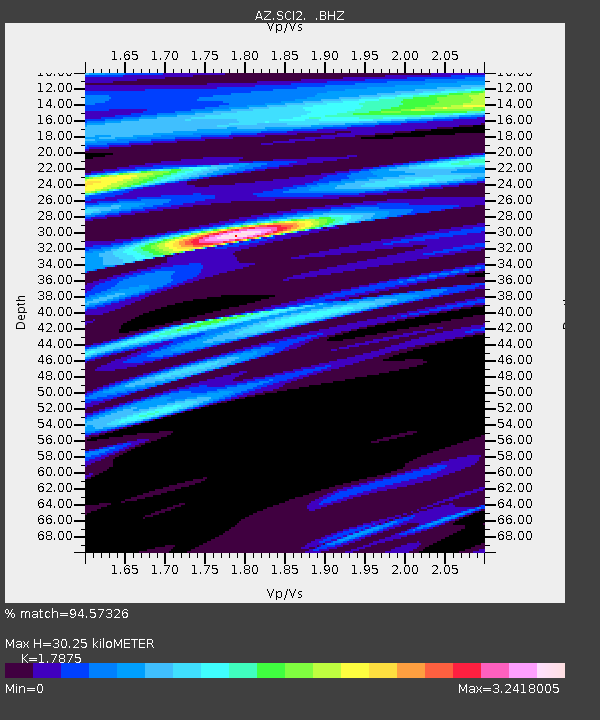
| Estimated Moho Depth: |
30.25 km |
| Estimated Crust Vp/Vs: |
1.79 |
| Assumed Crust Vp: |
6.048 km/s |
| Estimated Crust Vs: |
3.383 km/s |
| Estimated Crust Poisson's Ratio: |
0.27 |
|
| Radial Match: |
94.57326 % |
| Radial Bump: |
333 |
| Transverse Match: |
75.211784 % |
| Transverse Bump: |
400 |
| SOD ConfigId: |
494114 |
| Insert Time: |
2013-05-01 04:12:37.276 +0000 |
| GWidth: |
2.5 |
| Max Bumps: |
400 |
| Tol: |
0.001 |
|

Signal To Noise
| Channel | StoN | STA | LTA |
| AZ:SCI2: :BHZ:20130206T00:19:23.678003Z | 1.995897 | 2.017723E-6 | 1.0109355E-6 |
| AZ:SCI2: :BHN:20130206T00:19:23.678003Z | 1.9145635 | 3.2784826E-6 | 1.7123916E-6 |
| AZ:SCI2: :BHE:20130206T00:19:23.678003Z | 2.6000326 | 6.817602E-6 | 2.6221214E-6 |
| Arrivals |
| Ps | 4.0 SECOND |
| PpPs | 14 SECOND |
| PsPs/PpSs | 18 SECOND |


