You are here: Home > Network List > GT - Global Telemetered Seismograph Network (USAF/USGS) Stations List
> Station BGCA Bogoin, Central African Republic > Earthquake Result Viewer
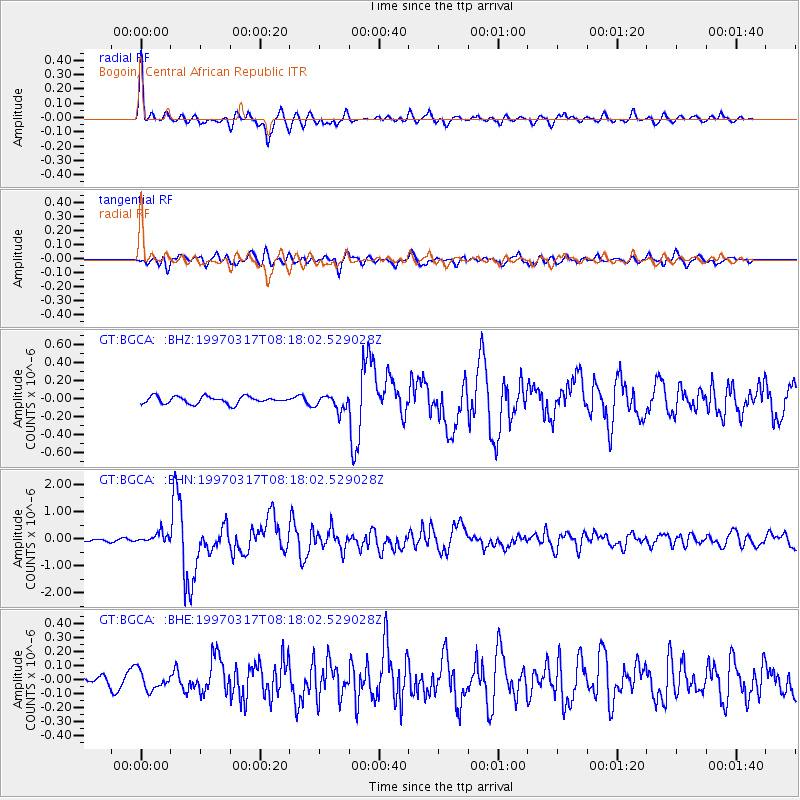
BGCA Bogoin, Central African Republic - Earthquake Result Viewer

| Earthquake location: |
Sunda Strait, Indonesia |
| Earthquake latitude/longitude: |
-6.6/105.5 |
| Earthquake time(UTC): |
1997/03/17 (076) 08:05:48 GMT |
| Earthquake Depth: |
33 km |
| Earthquake Magnitude: |
5.8 MB, 6.2 MS, 6.4 UNKNOWN, 6.3 MW |
| Earthquake Catalog/Contributor: |
WHDF/NEIC |
|
| Network: |
GT Global Telemetered Seismograph Network (USAF/USGS) |
| Station: |
BGCA Bogoin, Central African Republic |
| Lat/Lon: |
5.18 N/18.42 E |
| Elevation: |
676 m |
|
| Distance: |
87.7 deg |
| Az: |
275.445 deg |
| Baz: |
96.81 deg |
| Ray Param: |
0.043085825 |
| Estimated Moho Depth: |
39.75 km |
| Estimated Crust Vp/Vs: |
1.82 |
| Assumed Crust Vp: |
6.642 km/s |
| Estimated Crust Vs: |
3.659 km/s |
| Estimated Crust Poisson's Ratio: |
0.28 |
|
| Radial Match: |
94.29916 % |
| Radial Bump: |
400 |
| Transverse Match: |
82.414276 % |
| Transverse Bump: |
400 |
| SOD ConfigId: |
4480 |
| Insert Time: |
2010-02-27 01:39:46.702 +0000 |
| GWidth: |
2.5 |
| Max Bumps: |
400 |
| Tol: |
0.001 |
|
Signal To Noise
| Channel | StoN | STA | LTA |
| GT:BGCA: :BHN:19970317T08:18:02.529028Z | 3.8638542 | 1.8824129E-7 | 4.871853E-8 |
| GT:BGCA: :BHE:19970317T08:18:02.529028Z | 1.0357636 | 6.4493896E-8 | 6.2267006E-8 |
| GT:BGCA: :BHZ:19970317T08:18:02.529028Z | 2.1697116 | 8.615467E-8 | 3.9707892E-8 |
| Arrivals |
| Ps | 5.0 SECOND |
| PpPs | 16 SECOND |
| PsPs/PpSs | 21 SECOND |


