You are here: Home > Network List > AZ - ANZA Regional Network Stations List
> Station KNW AZ.KNW > Earthquake Result Viewer
KNW AZ.KNW - Earthquake Result Viewer

| Earthquake location: |
Santa Cruz Islands |
| Earthquake latitude/longitude: |
-10.8/165.1 |
| Earthquake time(UTC): |
2013/02/06 (037) 01:12:25 GMT |
| Earthquake Depth: |
24 km |
| Earthquake Magnitude: |
6.4 MB, 7.4 MS, 8.0 MW, 7.9 MW |
| Earthquake Catalog/Contributor: |
WHDF/NEIC |
|
| Network: |
AZ ANZA Regional Network |
| Station: |
KNW AZ.KNW |
| Lat/Lon: |
33.71 N/116.71 W |
| Elevation: |
1507 m |
|
| Distance: |
86.3 deg |
| Az: |
54.842 deg |
| Baz: |
254.516 deg |
| Ray Param: |
0.044144016 |
| Estimated Moho Depth: |
27.5 km |
| Estimated Crust Vp/Vs: |
2.10 |
| Assumed Crust Vp: |
6.264 km/s |
| Estimated Crust Vs: |
2.986 km/s |
| Estimated Crust Poisson's Ratio: |
0.35 |
|
| Radial Match: |
96.96618 % |
| Radial Bump: |
264 |
| Transverse Match: |
92.43193 % |
| Transverse Bump: |
400 |
| SOD ConfigId: |
494114 |
| Insert Time: |
2013-05-01 04:22:10.157 +0000 |
| GWidth: |
2.5 |
| Max Bumps: |
400 |
| Tol: |
0.001 |
|
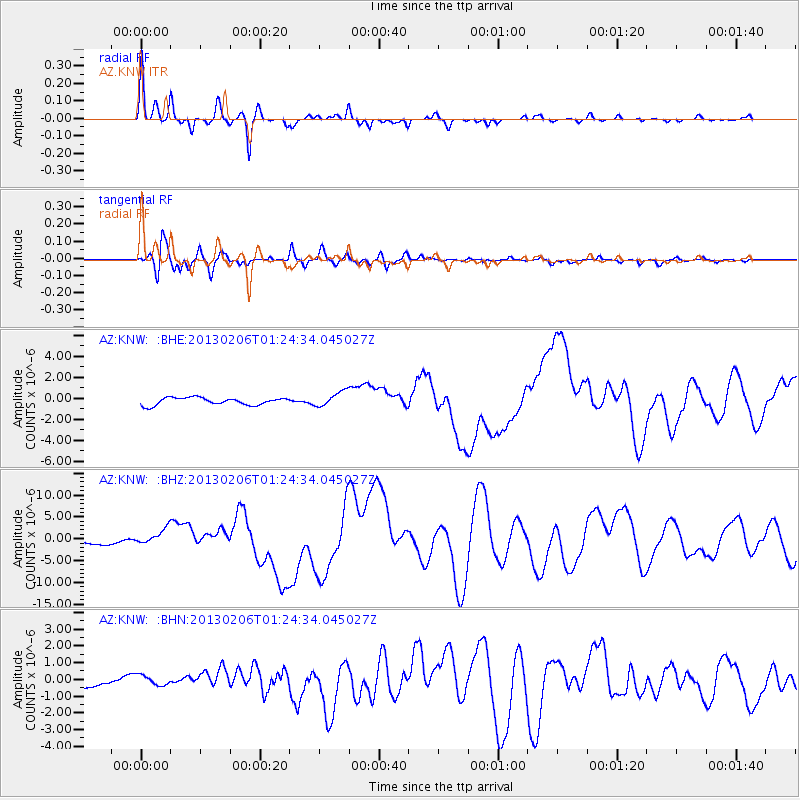
Signal To Noise
| Channel | StoN | STA | LTA |
| AZ:KNW: :BHZ:20130206T01:24:34.045027Z | 3.4562201 | 1.8262527E-6 | 5.2839596E-7 |
| AZ:KNW: :BHN:20130206T01:24:34.045027Z | 1.2592645 | 3.1824922E-7 | 2.527263E-7 |
| AZ:KNW: :BHE:20130206T01:24:34.045027Z | 2.0887234 | 7.218076E-7 | 3.4557357E-7 |
| Arrivals |
| Ps | 4.9 SECOND |
| PpPs | 13 SECOND |
| PsPs/PpSs | 18 SECOND |


