You are here: Home > Network List > AZ - ANZA Regional Network Stations List
> Station SCI2 San Clemente Island, CA, USA > Earthquake Result Viewer
SCI2 San Clemente Island, CA, USA - Earthquake Result Viewer
| Earthquake location: |
Santa Cruz Islands |
| Earthquake latitude/longitude: |
-10.8/165.1 |
| Earthquake time(UTC): |
2013/02/06 (037) 01:12:25 GMT |
| Earthquake Depth: |
24 km |
| Earthquake Magnitude: |
6.4 MB, 7.4 MS, 8.0 MW, 7.9 MW |
| Earthquake Catalog/Contributor: |
WHDF/NEIC |
|
| Network: |
AZ ANZA Regional Network |
| Station: |
SCI2 San Clemente Island, CA, USA |
| Lat/Lon: |
32.92 N/118.49 W |
| Elevation: |
486 m |
|
| Distance: |
84.6 deg |
| Az: |
55.201 deg |
| Baz: |
253.573 deg |
| Ray Param: |
0.04532325 |
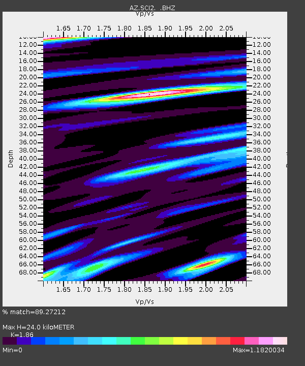
| Estimated Moho Depth: |
24.0 km |
| Estimated Crust Vp/Vs: |
1.86 |
| Assumed Crust Vp: |
6.048 km/s |
| Estimated Crust Vs: |
3.252 km/s |
| Estimated Crust Poisson's Ratio: |
0.30 |
|
| Radial Match: |
89.27212 % |
| Radial Bump: |
400 |
| Transverse Match: |
75.17891 % |
| Transverse Bump: |
400 |
| SOD ConfigId: |
494114 |
| Insert Time: |
2013-05-01 04:23:01.375 +0000 |
| GWidth: |
2.5 |
| Max Bumps: |
400 |
| Tol: |
0.001 |
|

Signal To Noise
| Channel | StoN | STA | LTA |
| AZ:SCI2: :BHZ:20130206T01:24:25.85301Z | 2.8938537 | 1.9361887E-6 | 6.690693E-7 |
| AZ:SCI2: :BHN:20130206T01:24:25.85301Z | 0.93727785 | 8.77383E-7 | 9.36097E-7 |
| AZ:SCI2: :BHE:20130206T01:24:25.85301Z | 1.6422671 | 1.2363353E-6 | 7.5282225E-7 |
| Arrivals |
| Ps | 3.5 SECOND |
| PpPs | 11 SECOND |
| PsPs/PpSs | 15 SECOND |


