You are here: Home > Network List > BK - Berkeley Digital Seismograph Network Stations List
> Station MCCM Marconi Conference Center, Marshall, CA, USA > Earthquake Result Viewer
MCCM Marconi Conference Center, Marshall, CA, USA - Earthquake Result Viewer
| Earthquake location: |
Santa Cruz Islands |
| Earthquake latitude/longitude: |
-10.8/165.1 |
| Earthquake time(UTC): |
2013/02/06 (037) 01:12:25 GMT |
| Earthquake Depth: |
24 km |
| Earthquake Magnitude: |
6.4 MB, 7.4 MS, 8.0 MW, 7.9 MW |
| Earthquake Catalog/Contributor: |
WHDF/NEIC |
|
| Network: |
BK Berkeley Digital Seismograph Network |
| Station: |
MCCM Marconi Conference Center, Marshall, CA, USA |
| Lat/Lon: |
38.14 N/122.88 W |
| Elevation: |
-7.7 m |
|
| Distance: |
82.8 deg |
| Az: |
49.096 deg |
| Baz: |
250.361 deg |
| Ray Param: |
0.046589352 |
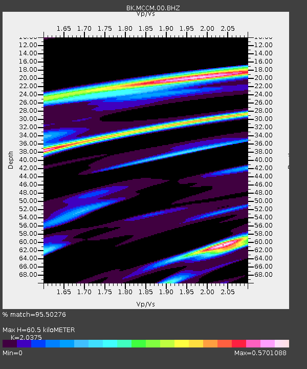
| Estimated Moho Depth: |
60.5 km |
| Estimated Crust Vp/Vs: |
2.04 |
| Assumed Crust Vp: |
6.472 km/s |
| Estimated Crust Vs: |
3.176 km/s |
| Estimated Crust Poisson's Ratio: |
0.34 |
|
| Radial Match: |
95.50276 % |
| Radial Bump: |
370 |
| Transverse Match: |
73.718346 % |
| Transverse Bump: |
400 |
| SOD ConfigId: |
494114 |
| Insert Time: |
2013-05-01 04:23:31.883 +0000 |
| GWidth: |
2.5 |
| Max Bumps: |
400 |
| Tol: |
0.001 |
|

Signal To Noise
| Channel | StoN | STA | LTA |
| BK:MCCM:00:BHZ:20130206T01:24:16.69499Z | 5.160291 | 3.1164363E-6 | 6.039265E-7 |
| BK:MCCM:00:BHN:20130206T01:24:16.69499Z | 1.0395155 | 4.5512706E-7 | 4.3782615E-7 |
| BK:MCCM:00:BHE:20130206T01:24:16.69499Z | 1.2400866 | 7.984198E-7 | 6.4384204E-7 |
| Arrivals |
| Ps | 9.9 SECOND |
| PpPs | 28 SECOND |
| PsPs/PpSs | 38 SECOND |


