You are here: Home > Network List > CC - Cascade Chain Volcano Monitoring Stations List
> Station OBSR Observation Rock, Mt. Rainier, WA > Earthquake Result Viewer
OBSR Observation Rock, Mt. Rainier, WA - Earthquake Result Viewer
| Earthquake location: |
Santa Cruz Islands |
| Earthquake latitude/longitude: |
-10.8/165.1 |
| Earthquake time(UTC): |
2013/02/06 (037) 01:12:25 GMT |
| Earthquake Depth: |
24 km |
| Earthquake Magnitude: |
6.4 MB, 7.4 MS, 8.0 MW, 7.9 MW |
| Earthquake Catalog/Contributor: |
WHDF/NEIC |
|
| Network: |
CC Cascade Chain Volcano Monitoring |
| Station: |
OBSR Observation Rock, Mt. Rainier, WA |
| Lat/Lon: |
46.90 N/121.82 W |
| Elevation: |
2382 m |
|
| Distance: |
86.5 deg |
| Az: |
41.088 deg |
| Baz: |
250.335 deg |
| Ray Param: |
0.04396735 |
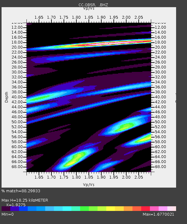
| Estimated Moho Depth: |
18.25 km |
| Estimated Crust Vp/Vs: |
1.93 |
| Assumed Crust Vp: |
6.597 km/s |
| Estimated Crust Vs: |
3.423 km/s |
| Estimated Crust Poisson's Ratio: |
0.32 |
|
| Radial Match: |
88.29933 % |
| Radial Bump: |
400 |
| Transverse Match: |
76.69037 % |
| Transverse Bump: |
400 |
| SOD ConfigId: |
494114 |
| Insert Time: |
2013-05-01 04:23:42.581 +0000 |
| GWidth: |
2.5 |
| Max Bumps: |
400 |
| Tol: |
0.001 |
|

Signal To Noise
| Channel | StoN | STA | LTA |
| CC:OBSR: :BHZ:20130206T01:24:35.239973Z | 3.2737753 | 1.5571211E-6 | 4.756347E-7 |
| CC:OBSR: :BHN:20130206T01:24:35.239973Z | 0.74843985 | 3.9600886E-7 | 5.2911247E-7 |
| CC:OBSR: :BHE:20130206T01:24:35.239973Z | 1.2056276 | 1.0610639E-6 | 8.8009256E-7 |
| Arrivals |
| Ps | 2.6 SECOND |
| PpPs | 7.9 SECOND |
| PsPs/PpSs | 11 SECOND |


