You are here: Home > Network List > CI - Caltech Regional Seismic Network Stations List
> Station RPV Rancho Palos Verdes, California, USA > Earthquake Result Viewer
RPV Rancho Palos Verdes, California, USA - Earthquake Result Viewer
| Earthquake location: |
Santa Cruz Islands |
| Earthquake latitude/longitude: |
-10.8/165.1 |
| Earthquake time(UTC): |
2013/02/06 (037) 01:12:25 GMT |
| Earthquake Depth: |
24 km |
| Earthquake Magnitude: |
6.4 MB, 7.4 MS, 8.0 MW, 7.9 MW |
| Earthquake Catalog/Contributor: |
WHDF/NEIC |
|
| Network: |
CI Caltech Regional Seismic Network |
| Station: |
RPV Rancho Palos Verdes, California, USA |
| Lat/Lon: |
33.74 N/118.40 W |
| Elevation: |
64 m |
|
| Distance: |
84.9 deg |
| Az: |
54.425 deg |
| Baz: |
253.548 deg |
| Ray Param: |
0.04510703 |
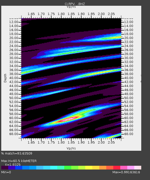
| Estimated Moho Depth: |
60.5 km |
| Estimated Crust Vp/Vs: |
1.83 |
| Assumed Crust Vp: |
6.048 km/s |
| Estimated Crust Vs: |
3.3 km/s |
| Estimated Crust Poisson's Ratio: |
0.29 |
|
| Radial Match: |
93.63509 % |
| Radial Bump: |
400 |
| Transverse Match: |
80.845695 % |
| Transverse Bump: |
400 |
| SOD ConfigId: |
494114 |
| Insert Time: |
2013-05-01 04:25:12.784 +0000 |
| GWidth: |
2.5 |
| Max Bumps: |
400 |
| Tol: |
0.001 |
|
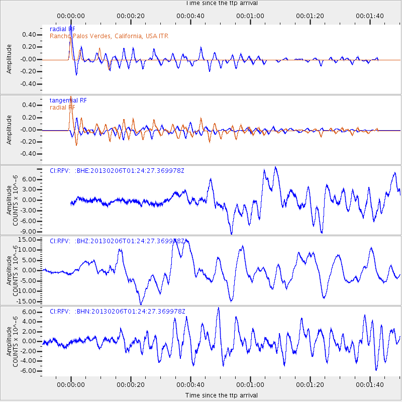
Signal To Noise
| Channel | StoN | STA | LTA |
| CI:RPV: :BHZ:20130206T01:24:27.369978Z | 5.3934345 | 2.4008732E-6 | 4.4514735E-7 |
| CI:RPV: :BHN:20130206T01:24:27.369978Z | 0.68017584 | 3.337742E-7 | 4.907176E-7 |
| CI:RPV: :BHE:20130206T01:24:27.369978Z | 2.0359662 | 1.0944677E-6 | 5.375668E-7 |
| Arrivals |
| Ps | 8.5 SECOND |
| PpPs | 28 SECOND |
| PsPs/PpSs | 36 SECOND |


