You are here: Home > Network List > CI - Caltech Regional Seismic Network Stations List
> Station FMP Fort MacArthur Park, Pt. Fermin San Pedro, CA, USA > Earthquake Result Viewer
FMP Fort MacArthur Park, Pt. Fermin San Pedro, CA, USA - Earthquake Result Viewer
| Earthquake location: |
Santa Cruz Islands |
| Earthquake latitude/longitude: |
-10.8/165.1 |
| Earthquake time(UTC): |
2013/02/06 (037) 01:12:25 GMT |
| Earthquake Depth: |
24 km |
| Earthquake Magnitude: |
6.4 MB, 7.4 MS, 8.0 MW, 7.9 MW |
| Earthquake Catalog/Contributor: |
WHDF/NEIC |
|
| Network: |
CI Caltech Regional Seismic Network |
| Station: |
FMP Fort MacArthur Park, Pt. Fermin San Pedro, CA, USA |
| Lat/Lon: |
33.71 N/118.29 W |
| Elevation: |
89 m |
|
| Distance: |
85.0 deg |
| Az: |
54.481 deg |
| Baz: |
253.614 deg |
| Ray Param: |
0.04504978 |
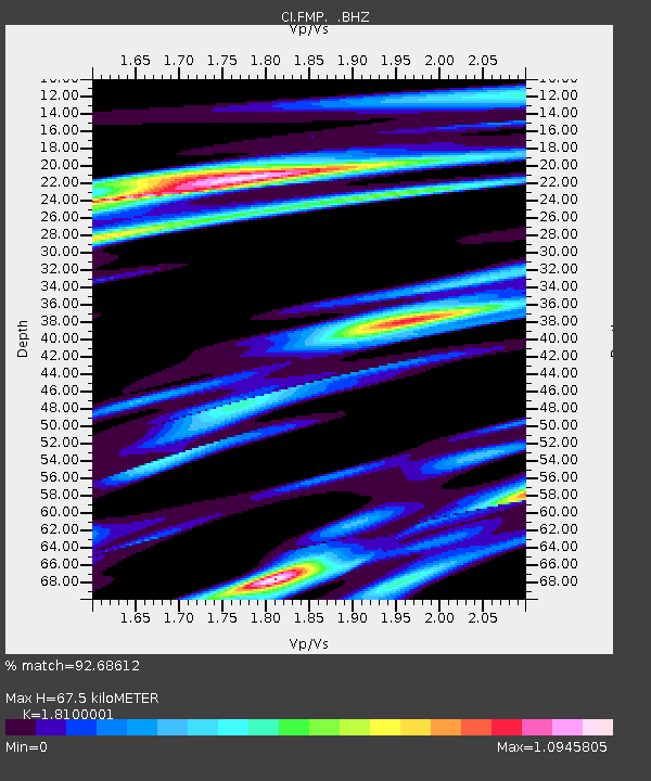
| Estimated Moho Depth: |
67.5 km |
| Estimated Crust Vp/Vs: |
1.81 |
| Assumed Crust Vp: |
6.048 km/s |
| Estimated Crust Vs: |
3.341 km/s |
| Estimated Crust Poisson's Ratio: |
0.28 |
|
| Radial Match: |
92.68612 % |
| Radial Bump: |
400 |
| Transverse Match: |
85.16446 % |
| Transverse Bump: |
400 |
| SOD ConfigId: |
494114 |
| Insert Time: |
2013-05-01 04:27:04.103 +0000 |
| GWidth: |
2.5 |
| Max Bumps: |
400 |
| Tol: |
0.001 |
|

Signal To Noise
| Channel | StoN | STA | LTA |
| CI:FMP: :BHZ:20130206T01:24:27.770002Z | 6.545835 | 2.3017737E-6 | 3.5163941E-7 |
| CI:FMP: :BHN:20130206T01:24:27.770002Z | 0.621622 | 3.3203722E-7 | 5.3414647E-7 |
| CI:FMP: :BHE:20130206T01:24:27.770002Z | 1.5309751 | 8.0888003E-7 | 5.2834304E-7 |
| Arrivals |
| Ps | 9.2 SECOND |
| PpPs | 31 SECOND |
| PsPs/PpSs | 40 SECOND |


