You are here: Home > Network List > CI - Caltech Regional Seismic Network Stations List
> Station SCZ2 SCZ2, Santa Cruz Is. (E end), CA, USA > Earthquake Result Viewer
SCZ2 SCZ2, Santa Cruz Is. (E end), CA, USA - Earthquake Result Viewer

| Earthquake location: |
Santa Cruz Islands |
| Earthquake latitude/longitude: |
-10.8/165.1 |
| Earthquake time(UTC): |
2013/02/06 (037) 01:12:25 GMT |
| Earthquake Depth: |
24 km |
| Earthquake Magnitude: |
6.4 MB, 7.4 MS, 8.0 MW, 7.9 MW |
| Earthquake Catalog/Contributor: |
WHDF/NEIC |
|
| Network: |
CI Caltech Regional Seismic Network |
| Station: |
SCZ2 SCZ2, Santa Cruz Is. (E end), CA, USA |
| Lat/Lon: |
34.00 N/119.64 W |
| Elevation: |
440 m |
|
| Distance: |
84.0 deg |
| Az: |
53.885 deg |
| Baz: |
252.814 deg |
| Ray Param: |
0.045750596 |
| Estimated Moho Depth: |
53.0 km |
| Estimated Crust Vp/Vs: |
1.80 |
| Assumed Crust Vp: |
6.048 km/s |
| Estimated Crust Vs: |
3.369 km/s |
| Estimated Crust Poisson's Ratio: |
0.27 |
|
| Radial Match: |
93.83356 % |
| Radial Bump: |
400 |
| Transverse Match: |
81.04726 % |
| Transverse Bump: |
400 |
| SOD ConfigId: |
494114 |
| Insert Time: |
2013-05-01 04:27:52.234 +0000 |
| GWidth: |
2.5 |
| Max Bumps: |
400 |
| Tol: |
0.001 |
|
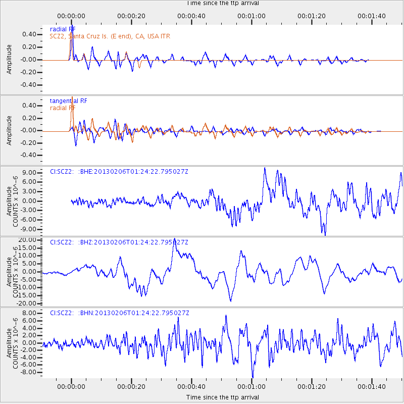
Signal To Noise
| Channel | StoN | STA | LTA |
| CI:SCZ2: :BHZ:20130206T01:24:22.795027Z | 5.2898736 | 2.6018524E-6 | 4.918553E-7 |
| CI:SCZ2: :BHN:20130206T01:24:22.795027Z | 0.7141891 | 6.232474E-7 | 8.726644E-7 |
| CI:SCZ2: :BHE:20130206T01:24:22.795027Z | 1.6612697 | 1.2284434E-6 | 7.394606E-7 |
| Arrivals |
| Ps | 7.1 SECOND |
| PpPs | 24 SECOND |
| PsPs/PpSs | 31 SECOND |


