You are here: Home > Network List > CN - Canadian National Seismograph Network Stations List
> Station LLLB LILLOOET, BC, CANADA ADA > Earthquake Result Viewer
LLLB LILLOOET, BC, CANADA ADA - Earthquake Result Viewer
| Earthquake location: |
Santa Cruz Islands |
| Earthquake latitude/longitude: |
-10.8/165.1 |
| Earthquake time(UTC): |
2013/02/06 (037) 01:12:25 GMT |
| Earthquake Depth: |
24 km |
| Earthquake Magnitude: |
6.4 MB, 7.4 MS, 8.0 MW, 7.9 MW |
| Earthquake Catalog/Contributor: |
WHDF/NEIC |
|
| Network: |
CN Canadian National Seismograph Network |
| Station: |
LLLB LILLOOET, BC, CANADA ADA |
| Lat/Lon: |
50.61 N/121.88 W |
| Elevation: |
700 m |
|
| Distance: |
87.7 deg |
| Az: |
37.575 deg |
| Baz: |
250.11 deg |
| Ray Param: |
0.043083377 |
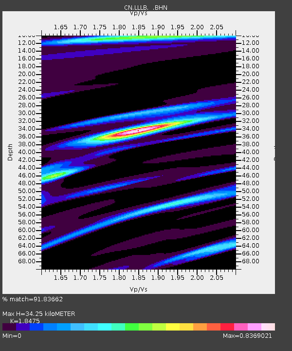
| Estimated Moho Depth: |
34.25 km |
| Estimated Crust Vp/Vs: |
1.85 |
| Assumed Crust Vp: |
6.597 km/s |
| Estimated Crust Vs: |
3.571 km/s |
| Estimated Crust Poisson's Ratio: |
0.29 |
|
| Radial Match: |
91.83662 % |
| Radial Bump: |
400 |
| Transverse Match: |
58.404427 % |
| Transverse Bump: |
400 |
| SOD ConfigId: |
494114 |
| Insert Time: |
2013-05-01 04:28:42.718 +0000 |
| GWidth: |
2.5 |
| Max Bumps: |
400 |
| Tol: |
0.001 |
|
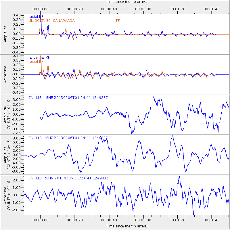
Signal To Noise
| Channel | StoN | STA | LTA |
| CN:LLLB: :BHZ:20130206T01:24:41.124983Z | 3.367108 | 1.4111681E-6 | 4.1910388E-7 |
| CN:LLLB: :BHN:20130206T01:24:41.124983Z | 0.8713907 | 3.396529E-7 | 3.8978254E-7 |
| CN:LLLB: :BHE:20130206T01:24:41.124983Z | 2.093827 | 5.7739743E-7 | 2.7576178E-7 |
| Arrivals |
| Ps | 4.5 SECOND |
| PpPs | 14 SECOND |
| PsPs/PpSs | 19 SECOND |


