You are here: Home > Network List > G - GEOSCOPE Stations List
> Station TAOE Taiohae, Marquises islands > Earthquake Result Viewer
TAOE Taiohae, Marquises islands - Earthquake Result Viewer
| Earthquake location: |
Santa Cruz Islands |
| Earthquake latitude/longitude: |
-10.8/165.1 |
| Earthquake time(UTC): |
2013/02/06 (037) 01:12:25 GMT |
| Earthquake Depth: |
24 km |
| Earthquake Magnitude: |
6.4 MB, 7.4 MS, 8.0 MW, 7.9 MW |
| Earthquake Catalog/Contributor: |
WHDF/NEIC |
|
| Network: |
G GEOSCOPE |
| Station: |
TAOE Taiohae, Marquises islands |
| Lat/Lon: |
8.85 S/140.15 W |
| Elevation: |
800 m |
|
| Distance: |
53.9 deg |
| Az: |
93.125 deg |
| Baz: |
263.09 deg |
| Ray Param: |
0.06574523 |
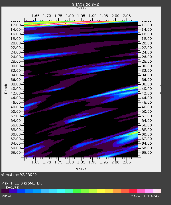
| Estimated Moho Depth: |
11.0 km |
| Estimated Crust Vp/Vs: |
1.78 |
| Assumed Crust Vp: |
4.24 km/s |
| Estimated Crust Vs: |
2.382 km/s |
| Estimated Crust Poisson's Ratio: |
0.27 |
|
| Radial Match: |
93.03022 % |
| Radial Bump: |
319 |
| Transverse Match: |
67.52333 % |
| Transverse Bump: |
400 |
| SOD ConfigId: |
494114 |
| Insert Time: |
2013-05-01 04:28:51.758 +0000 |
| GWidth: |
2.5 |
| Max Bumps: |
400 |
| Tol: |
0.001 |
|
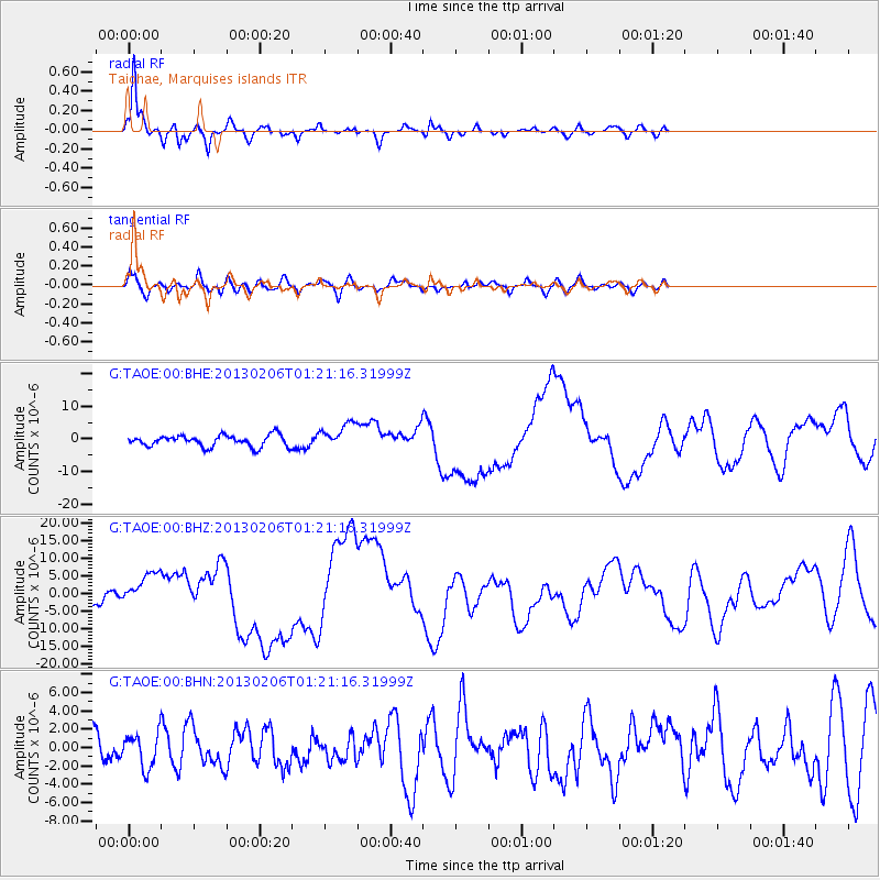
Signal To Noise
| Channel | StoN | STA | LTA |
| G:TAOE:00:BHZ:20130206T01:21:16.31999Z | 2.7633846 | 4.7071335E-6 | 1.7033943E-6 |
| G:TAOE:00:BHN:20130206T01:21:16.31999Z | 1.1474997 | 1.8100145E-6 | 1.5773551E-6 |
| G:TAOE:00:BHE:20130206T01:21:16.31999Z | 2.2278695 | 3.8345383E-6 | 1.7211682E-6 |
| Arrivals |
| Ps | 2.1 SECOND |
| PpPs | 7.1 SECOND |
| PsPs/PpSs | 9.1 SECOND |


