You are here: Home > Network List > TA - USArray Transportable Network (new EarthScope stations) Stations List
> Station 109C Camp Elliot, Mirimar, CA, USA > Earthquake Result Viewer
109C Camp Elliot, Mirimar, CA, USA - Earthquake Result Viewer
| Earthquake location: |
Santa Cruz Islands |
| Earthquake latitude/longitude: |
-10.8/165.1 |
| Earthquake time(UTC): |
2013/02/06 (037) 01:12:25 GMT |
| Earthquake Depth: |
24 km |
| Earthquake Magnitude: |
6.4 MB, 7.4 MS, 8.0 MW, 7.9 MW |
| Earthquake Catalog/Contributor: |
WHDF/NEIC |
|
| Network: |
TA USArray Transportable Network (new EarthScope stations) |
| Station: |
109C Camp Elliot, Mirimar, CA, USA |
| Lat/Lon: |
32.89 N/117.11 W |
| Elevation: |
150 m |
|
| Distance: |
85.7 deg |
| Az: |
55.548 deg |
| Baz: |
254.35 deg |
| Ray Param: |
0.044525832 |
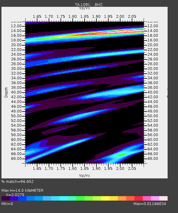
| Estimated Moho Depth: |
14.0 km |
| Estimated Crust Vp/Vs: |
2.03 |
| Assumed Crust Vp: |
6.264 km/s |
| Estimated Crust Vs: |
3.089 km/s |
| Estimated Crust Poisson's Ratio: |
0.34 |
|
| Radial Match: |
96.652 % |
| Radial Bump: |
342 |
| Transverse Match: |
90.095146 % |
| Transverse Bump: |
400 |
| SOD ConfigId: |
494114 |
| Insert Time: |
2013-05-01 04:31:52.474 +0000 |
| GWidth: |
2.5 |
| Max Bumps: |
400 |
| Tol: |
0.001 |
|

Signal To Noise
| Channel | StoN | STA | LTA |
| TA:109C: :BHZ:20130206T01:24:31.395002Z | 4.785145 | 2.2075426E-6 | 4.6133246E-7 |
| TA:109C: :BHN:20130206T01:24:31.395002Z | 2.9064622 | 3.6039356E-7 | 1.2399734E-7 |
| TA:109C: :BHE:20130206T01:24:31.395002Z | 2.9642417 | 8.539206E-7 | 2.8807386E-7 |
| Arrivals |
| Ps | 2.3 SECOND |
| PpPs | 6.6 SECOND |
| PsPs/PpSs | 9.0 SECOND |


