You are here: Home > Network List > TA - USArray Transportable Network (new EarthScope stations) Stations List
> Station MSTX Muleshoe, TX, USA > Earthquake Result Viewer
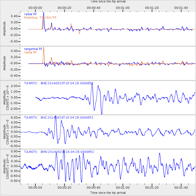
MSTX Muleshoe, TX, USA - Earthquake Result Viewer
*The percent match for this event was below the threshold and hence no stack was calculated.
| Earthquake location: |
Samoa Islands Region |
| Earthquake latitude/longitude: |
-14.8/-175.3 |
| Earthquake time(UTC): |
2014/06/29 (180) 15:52:22 GMT |
| Earthquake Depth: |
10 km |
| Earthquake Magnitude: |
6.4 MWW, 6.4 MWB, 6.5 MWC, 6.8 MI |
| Earthquake Catalog/Contributor: |
NEIC PDE/NEIC COMCAT |
|
| Network: |
TA USArray Transportable Network (new EarthScope stations) |
| Station: |
MSTX Muleshoe, TX, USA |
| Lat/Lon: |
33.97 N/102.77 W |
| Elevation: |
1167 m |
|
| Distance: |
84.2 deg |
| Az: |
52.81 deg |
| Baz: |
248.02 deg |
| Ray Param: |
$rayparam |
*The percent match for this event was below the threshold and hence was not used in the summary stack. |
|
| Radial Match: |
94.990944 % |
| Radial Bump: |
304 |
| Transverse Match: |
78.39513 % |
| Transverse Bump: |
400 |
| SOD ConfigId: |
3390531 |
| Insert Time: |
2019-04-12 14:33:44.552 +0000 |
| GWidth: |
2.5 |
| Max Bumps: |
400 |
| Tol: |
0.001 |
|
Signal To Noise
| Channel | StoN | STA | LTA |
| TA:MSTX: :BHZ:20140629T16:04:28.099985Z | 2.2012246 | 1.8215233E-7 | 8.2750454E-8 |
| TA:MSTX: :BHN:20140629T16:04:28.099985Z | 0.8017407 | 1.07033834E-7 | 1.3350181E-7 |
| TA:MSTX: :BHE:20140629T16:04:28.099985Z | 1.3097025 | 1.72004E-7 | 1.3133058E-7 |
| Arrivals |
| Ps | |
| PpPs | |
| PsPs/PpSs | |


