You are here: Home > Network List > TA - USArray Transportable Network (new EarthScope stations) Stations List
> Station M04C Macdoel, CA, USA > Earthquake Result Viewer
M04C Macdoel, CA, USA - Earthquake Result Viewer

| Earthquake location: |
Santa Cruz Islands |
| Earthquake latitude/longitude: |
-10.8/165.1 |
| Earthquake time(UTC): |
2013/02/06 (037) 01:12:25 GMT |
| Earthquake Depth: |
24 km |
| Earthquake Magnitude: |
6.4 MB, 7.4 MS, 8.0 MW, 7.9 MW |
| Earthquake Catalog/Contributor: |
WHDF/NEIC |
|
| Network: |
TA USArray Transportable Network (new EarthScope stations) |
| Station: |
M04C Macdoel, CA, USA |
| Lat/Lon: |
41.78 N/121.84 W |
| Elevation: |
1391 m |
|
| Distance: |
84.8 deg |
| Az: |
45.919 deg |
| Baz: |
250.685 deg |
| Ray Param: |
0.045199946 |
| Estimated Moho Depth: |
17.0 km |
| Estimated Crust Vp/Vs: |
1.61 |
| Assumed Crust Vp: |
6.566 km/s |
| Estimated Crust Vs: |
4.072 km/s |
| Estimated Crust Poisson's Ratio: |
0.19 |
|
| Radial Match: |
91.78593 % |
| Radial Bump: |
400 |
| Transverse Match: |
76.65438 % |
| Transverse Bump: |
400 |
| SOD ConfigId: |
494114 |
| Insert Time: |
2013-05-01 04:32:04.067 +0000 |
| GWidth: |
2.5 |
| Max Bumps: |
400 |
| Tol: |
0.001 |
|
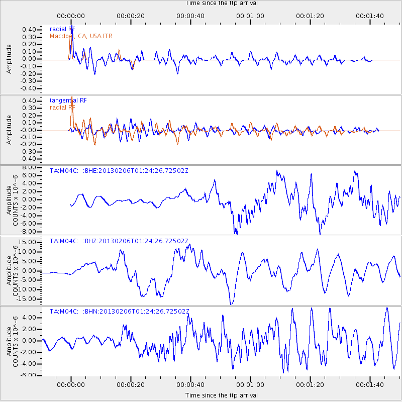
Signal To Noise
| Channel | StoN | STA | LTA |
| TA:M04C: :BHZ:20130206T01:24:26.72502Z | 3.9717786 | 1.8523025E-6 | 4.6636598E-7 |
| TA:M04C: :BHN:20130206T01:24:26.72502Z | 1.0236831 | 6.875754E-7 | 6.716682E-7 |
| TA:M04C: :BHE:20130206T01:24:26.72502Z | 1.0548843 | 8.4942235E-7 | 8.052279E-7 |
| Arrivals |
| Ps | 1.6 SECOND |
| PpPs | 6.6 SECOND |
| PsPs/PpSs | 8.2 SECOND |


