You are here: Home > Network List > TA - USArray Transportable Network (new EarthScope stations) Stations List
> Station Z41A Richland Creek Farm, El Dorado, AR, USA > Earthquake Result Viewer
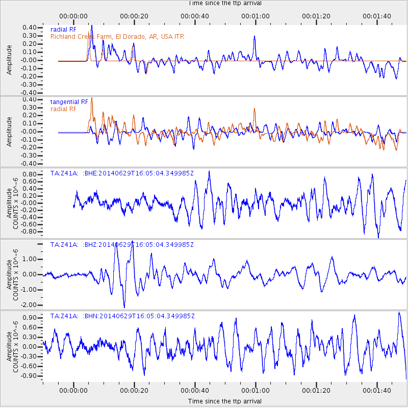
Z41A Richland Creek Farm, El Dorado, AR, USA - Earthquake Result Viewer
*The percent match for this event was below the threshold and hence no stack was calculated.
| Earthquake location: |
Samoa Islands Region |
| Earthquake latitude/longitude: |
-14.8/-175.3 |
| Earthquake time(UTC): |
2014/06/29 (180) 15:52:22 GMT |
| Earthquake Depth: |
10 km |
| Earthquake Magnitude: |
6.4 MWW, 6.4 MWB, 6.5 MWC, 6.8 MI |
| Earthquake Catalog/Contributor: |
NEIC PDE/NEIC COMCAT |
|
| Network: |
TA USArray Transportable Network (new EarthScope stations) |
| Station: |
Z41A Richland Creek Farm, El Dorado, AR, USA |
| Lat/Lon: |
33.26 N/92.80 W |
| Elevation: |
62 m |
|
| Distance: |
91.8 deg |
| Az: |
56.209 deg |
| Baz: |
253.641 deg |
| Ray Param: |
$rayparam |
*The percent match for this event was below the threshold and hence was not used in the summary stack. |
|
| Radial Match: |
80.34998 % |
| Radial Bump: |
400 |
| Transverse Match: |
75.54654 % |
| Transverse Bump: |
400 |
| SOD ConfigId: |
3390531 |
| Insert Time: |
2019-04-12 14:33:58.331 +0000 |
| GWidth: |
2.5 |
| Max Bumps: |
400 |
| Tol: |
0.001 |
|
Signal To Noise
| Channel | StoN | STA | LTA |
| TA:Z41A: :BHZ:20140629T16:05:04.349985Z | 0.5651444 | 5.3742355E-8 | 9.50949E-8 |
| TA:Z41A: :BHN:20140629T16:05:04.349985Z | 0.9308265 | 1.4857969E-7 | 1.5962124E-7 |
| TA:Z41A: :BHE:20140629T16:05:04.349985Z | 0.7807928 | 1.0422637E-7 | 1.3348787E-7 |
| Arrivals |
| Ps | |
| PpPs | |
| PsPs/PpSs | |


