You are here: Home > Network List > GT - Global Telemetered Seismograph Network (USAF/USGS) Stations List
> Station BGCA Bogoin, Central African Republic > Earthquake Result Viewer
BGCA Bogoin, Central African Republic - Earthquake Result Viewer
| Earthquake location: |
Myanmar |
| Earthquake latitude/longitude: |
26.9/97.2 |
| Earthquake time(UTC): |
2000/06/07 (159) 21:46:55 GMT |
| Earthquake Depth: |
33 km |
| Earthquake Magnitude: |
6.3 MB, 6.5 MS, 6.4 MW, 6.4 MW |
| Earthquake Catalog/Contributor: |
WHDF/NEIC |
|
| Network: |
GT Global Telemetered Seismograph Network (USAF/USGS) |
| Station: |
BGCA Bogoin, Central African Republic |
| Lat/Lon: |
5.18 N/18.42 E |
| Elevation: |
676 m |
|
| Distance: |
77.7 deg |
| Az: |
269.604 deg |
| Baz: |
63.76 deg |
| Ray Param: |
0.050092008 |
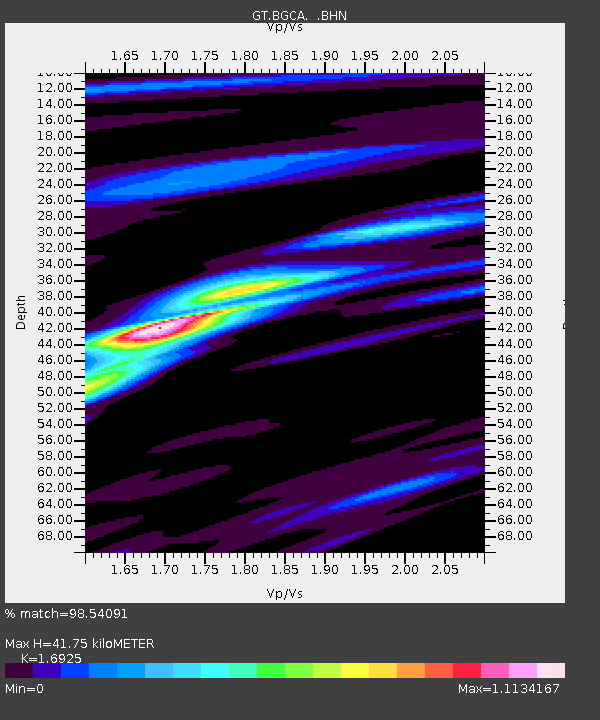
| Estimated Moho Depth: |
41.75 km |
| Estimated Crust Vp/Vs: |
1.69 |
| Assumed Crust Vp: |
6.642 km/s |
| Estimated Crust Vs: |
3.924 km/s |
| Estimated Crust Poisson's Ratio: |
0.23 |
|
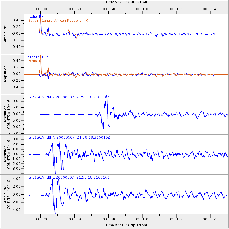
| Radial Match: |
98.54091 % |
| Radial Bump: |
311 |
| Transverse Match: |
91.85926 % |
| Transverse Bump: |
400 |
| SOD ConfigId: |
3744 |
| Insert Time: |
2010-02-27 01:40:35.689 +0000 |
| GWidth: |
2.5 |
| Max Bumps: |
400 |
| Tol: |
0.001 |
|
Signal To Noise
| Channel | StoN | STA | LTA |
| GT:BGCA: :BHN:20000607T21:58:18.316016Z | 2.4515102 | 1.0896262E-7 | 4.444714E-8 |
| GT:BGCA: :BHE:20000607T21:58:18.316016Z | 3.7421362 | 1.589014E-7 | 4.246275E-8 |
| GT:BGCA: :BHZ:20000607T21:58:18.316016Z | 10.8846245 | 4.5566924E-7 | 4.1863565E-8 |
| Arrivals |
| Ps | 4.5 SECOND |
| PpPs | 16 SECOND |
| PsPs/PpSs | 21 SECOND |


