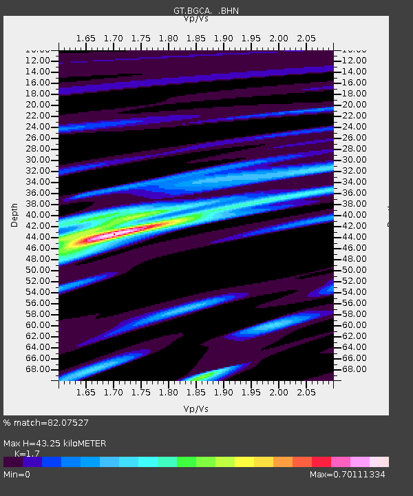
BGCA Bogoin, Central African Republic - Earthquake Result Viewer

Earthquake location: Southern Sumatra, Indonesia
Earthquake latitude/longitude: -5.1/102.7
Earthquake time(UTC): 2000/06/06 (158) 09:58:06 GMT
Earthquake Depth: 33 km
Earthquake Magnitude: 5.8 MB, 6.1 MS, 6.2 MW, 6.1 MW
Earthquake Catalog/Contributor: WHDF/NEIC
Network: GT Global Telemetered Seismograph Network (USAF/USGS)
Station: BGCA Bogoin, Central African Republic
Lat/Lon: 5.18 N/18.42 E
Elevation: 676 m
Distance: 84.8 deg
Az: 275.65 deg
Baz: 95.574 deg
Ray Param: 0.045197133
Estimated Moho Depth: 43.25 km
Estimated Crust Vp/Vs: 1.70
Assumed Crust Vp: 6.642 km/s
Estimated Crust Vs: 3.907 km/s
Estimated Crust Poisson's Ratio: 0.24
Radial Match: 82.07527 %
Radial Bump: 400
Transverse Match: 74.76575 %
Transverse Bump: 400
SOD ConfigId: 3744
Insert Time: 2010-02-27 01:40:38.411 +0000
GWidth: 2.5
Max Bumps: 400
Tol: 0.001

Signal To Noise

ChannelStoNSTALTA
GT:BGCA: :BHN:20000606T10:10:06.507Z2.52454768.1710525E-83.23664E-8
GT:BGCA: :BHE:20000606T10:10:06.507Z1.47983381.0053562E-76.79371E-8
GT:BGCA: :BHZ:20000606T10:10:06.507Z4.21464252.8592547E-76.784097E-8
Arrivals
Ps4.7 SECOND
PpPs17 SECOND
PsPs/PpSs22 SECOND