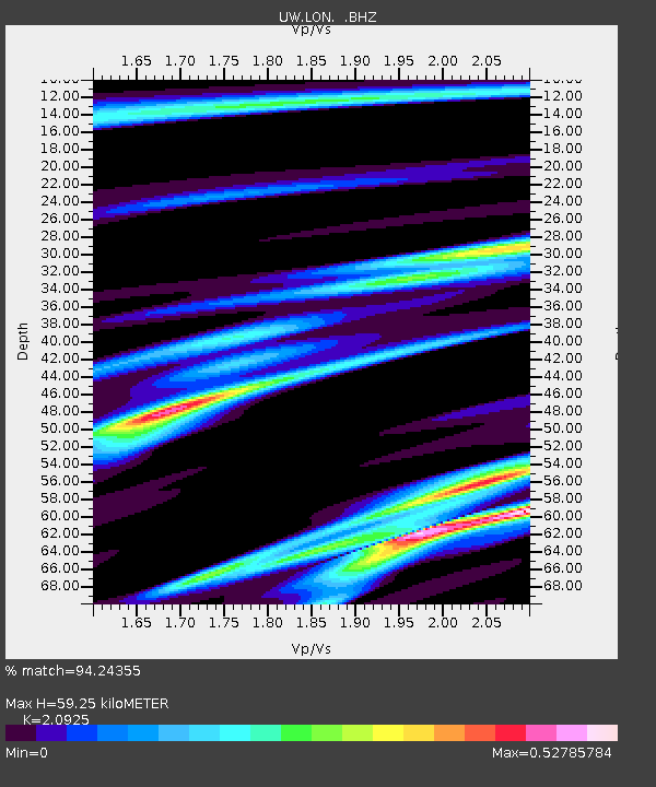
LON Longmire (broad-band and DWWSSN) - Earthquake Result Viewer

Earthquake location: Santa Cruz Islands
Earthquake latitude/longitude: -10.8/165.1
Earthquake time(UTC): 2013/02/06 (037) 01:12:25 GMT
Earthquake Depth: 24 km
Earthquake Magnitude: 6.4 MB, 7.4 MS, 8.0 MW, 7.9 MW
Earthquake Catalog/Contributor: WHDF/NEIC
Network: UW Pacific Northwest Regional Seismic Network
Station: LON Longmire (broad-band and DWWSSN)
Lat/Lon: 46.75 N/121.81 W
Elevation: 850 m
Distance: 86.5 deg
Az: 41.23 deg
Baz: 250.348 deg
Ray Param: 0.044001732
Estimated Moho Depth: 59.25 km
Estimated Crust Vp/Vs: 2.09
Assumed Crust Vp: 6.597 km/s
Estimated Crust Vs: 3.153 km/s
Estimated Crust Poisson's Ratio: 0.35
Radial Match: 94.24355 %
Radial Bump: 353
Transverse Match: 79.55508 %
Transverse Bump: 400
SOD ConfigId: 494114
Insert Time: 2013-05-01 04:35:44.582 +0000
GWidth: 2.5
Max Bumps: 400
Tol: 0.001

Signal To Noise

ChannelStoNSTALTA
UW:LON: :BHZ:20130206T01:24:35.025007Z5.1501532.0371904E-63.9555917E-7
UW:LON: :BHN:20130206T01:24:35.025007Z1.17097143.1664268E-72.7041028E-7
UW:LON: :BHE:20130206T01:24:35.025007Z2.06094438.448366E-74.0992694E-7
Arrivals
Ps10 SECOND
PpPs27 SECOND
PsPs/PpSs37 SECOND