You are here: Home > Network List > UW - Pacific Northwest Regional Seismic Network Stations List
> Station WOLL Wollman Farm, Schrag, WA, USA > Earthquake Result Viewer
WOLL Wollman Farm, Schrag, WA, USA - Earthquake Result Viewer

| Earthquake location: |
Santa Cruz Islands |
| Earthquake latitude/longitude: |
-10.8/165.1 |
| Earthquake time(UTC): |
2013/02/06 (037) 01:12:25 GMT |
| Earthquake Depth: |
24 km |
| Earthquake Magnitude: |
6.4 MB, 7.4 MS, 8.0 MW, 7.9 MW |
| Earthquake Catalog/Contributor: |
WHDF/NEIC |
|
| Network: |
UW Pacific Northwest Regional Seismic Network |
| Station: |
WOLL Wollman Farm, Schrag, WA, USA |
| Lat/Lon: |
47.06 N/118.92 W |
| Elevation: |
385 m |
|
| Distance: |
88.4 deg |
| Az: |
41.571 deg |
| Baz: |
252.466 deg |
| Ray Param: |
0.042553596 |
| Estimated Moho Depth: |
29.25 km |
| Estimated Crust Vp/Vs: |
1.80 |
| Assumed Crust Vp: |
6.419 km/s |
| Estimated Crust Vs: |
3.571 km/s |
| Estimated Crust Poisson's Ratio: |
0.28 |
|
| Radial Match: |
95.49343 % |
| Radial Bump: |
261 |
| Transverse Match: |
81.75011 % |
| Transverse Bump: |
379 |
| SOD ConfigId: |
494114 |
| Insert Time: |
2013-05-01 04:36:24.693 +0000 |
| GWidth: |
2.5 |
| Max Bumps: |
400 |
| Tol: |
0.001 |
|
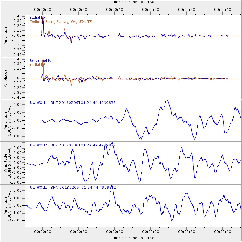
Signal To Noise
| Channel | StoN | STA | LTA |
| UW:WOLL: :BHZ:20130206T01:24:44.499983Z | 5.357151 | 2.1898832E-6 | 4.0877757E-7 |
| UW:WOLL: :BHN:20130206T01:24:44.499983Z | 1.9885266 | 5.6197223E-7 | 2.8260735E-7 |
| UW:WOLL: :BHE:20130206T01:24:44.499983Z | 2.0354984 | 6.4189635E-7 | 3.1535092E-7 |
| Arrivals |
| Ps | 3.7 SECOND |
| PpPs | 12 SECOND |
| PsPs/PpSs | 16 SECOND |


