You are here: Home > Network List > CI - Caltech Regional Seismic Network Stations List
> Station MPP McPhearson Peak > Earthquake Result Viewer
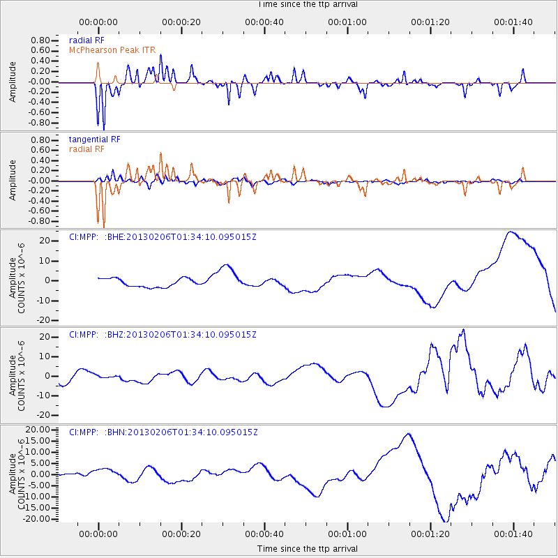
MPP McPhearson Peak - Earthquake Result Viewer
*The percent match for this event was below the threshold and hence no stack was calculated.
| Earthquake location: |
Santa Cruz Islands |
| Earthquake latitude/longitude: |
-11.3/165.9 |
| Earthquake time(UTC): |
2013/02/06 (037) 01:22:12 GMT |
| Earthquake Depth: |
13 km |
| Earthquake Magnitude: |
5.6 MB |
| Earthquake Catalog/Contributor: |
WHDF/NEIC |
|
| Network: |
CI Caltech Regional Seismic Network |
| Station: |
MPP McPhearson Peak |
| Lat/Lon: |
34.89 N/119.81 W |
| Elevation: |
1739 m |
|
| Distance: |
83.9 deg |
| Az: |
52.743 deg |
| Baz: |
251.724 deg |
| Ray Param: |
$rayparam |
*The percent match for this event was below the threshold and hence was not used in the summary stack. |
|
| Radial Match: |
88.68587 % |
| Radial Bump: |
267 |
| Transverse Match: |
56.54081 % |
| Transverse Bump: |
364 |
| SOD ConfigId: |
494114 |
| Insert Time: |
2013-05-01 04:47:41.867 +0000 |
| GWidth: |
2.5 |
| Max Bumps: |
400 |
| Tol: |
0.001 |
|
Signal To Noise
| Channel | StoN | STA | LTA |
| CI:MPP: :BHZ:20130206T01:34:10.095015Z | 0.3798516 | 9.135776E-7 | 2.4050908E-6 |
| CI:MPP: :BHN:20130206T01:34:10.095015Z | 1.4086758 | 2.6287544E-6 | 1.8661175E-6 |
| CI:MPP: :BHE:20130206T01:34:10.095015Z | 3.1521835 | 6.5271206E-6 | 2.0706664E-6 |
| Arrivals |
| Ps | |
| PpPs | |
| PsPs/PpSs | |


