You are here: Home > Network List > TA - USArray Transportable Network (new EarthScope stations) Stations List
> Station R11A Troy Canyon, Currant, NV, USA > Earthquake Result Viewer
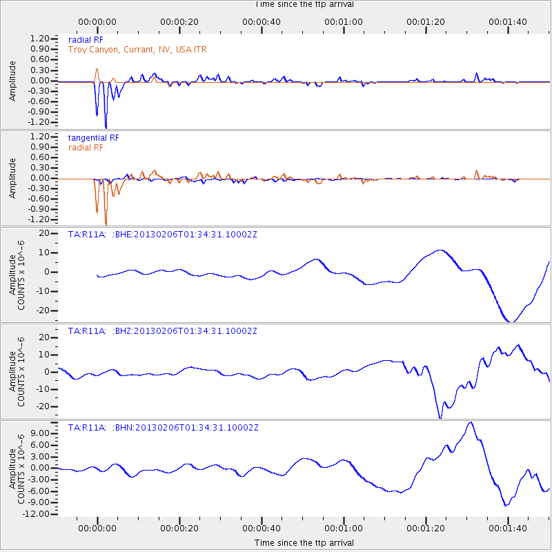
R11A Troy Canyon, Currant, NV, USA - Earthquake Result Viewer
*The percent match for this event was below the threshold and hence no stack was calculated.
| Earthquake location: |
Santa Cruz Islands |
| Earthquake latitude/longitude: |
-11.3/165.9 |
| Earthquake time(UTC): |
2013/02/06 (037) 01:22:12 GMT |
| Earthquake Depth: |
13 km |
| Earthquake Magnitude: |
5.6 MB |
| Earthquake Catalog/Contributor: |
WHDF/NEIC |
|
| Network: |
TA USArray Transportable Network (new EarthScope stations) |
| Station: |
R11A Troy Canyon, Currant, NV, USA |
| Lat/Lon: |
38.35 N/115.59 W |
| Elevation: |
1756 m |
|
| Distance: |
88.1 deg |
| Az: |
50.439 deg |
| Baz: |
254.075 deg |
| Ray Param: |
$rayparam |
*The percent match for this event was below the threshold and hence was not used in the summary stack. |
|
| Radial Match: |
88.029236 % |
| Radial Bump: |
168 |
| Transverse Match: |
75.57319 % |
| Transverse Bump: |
400 |
| SOD ConfigId: |
494114 |
| Insert Time: |
2013-05-01 04:50:16.924 +0000 |
| GWidth: |
2.5 |
| Max Bumps: |
400 |
| Tol: |
0.001 |
|
Signal To Noise
| Channel | StoN | STA | LTA |
| TA:R11A: :BHZ:20130206T01:34:31.10002Z | 0.6254839 | 1.2720276E-6 | 2.0336695E-6 |
| TA:R11A: :BHN:20130206T01:34:31.10002Z | 1.0003148 | 7.737247E-7 | 7.7348113E-7 |
| TA:R11A: :BHE:20130206T01:34:31.10002Z | 1.5329763 | 1.8031271E-6 | 1.1762264E-6 |
| Arrivals |
| Ps | |
| PpPs | |
| PsPs/PpSs | |


