You are here: Home > Network List > AV - Alaska Volcano Observatory Stations List
> Station KABU KABU - Katmai Volcanic Cluster, Alaska > Earthquake Result Viewer
KABU KABU - Katmai Volcanic Cluster, Alaska - Earthquake Result Viewer
| Earthquake location: |
Santa Cruz Islands Region |
| Earthquake latitude/longitude: |
-11.2/164.9 |
| Earthquake time(UTC): |
2013/02/06 (037) 01:23:19 GMT |
| Earthquake Depth: |
10 km |
| Earthquake Magnitude: |
6.6 MB, 7.1 MW, 7.1 MW |
| Earthquake Catalog/Contributor: |
WHDF/NEIC |
|
| Network: |
AV Alaska Volcano Observatory |
| Station: |
KABU KABU - Katmai Volcanic Cluster, Alaska |
| Lat/Lon: |
58.27 N/155.28 W |
| Elevation: |
1065 m |
|
| Distance: |
76.4 deg |
| Az: |
20.38 deg |
| Baz: |
220.288 deg |
| Ray Param: |
0.050998416 |
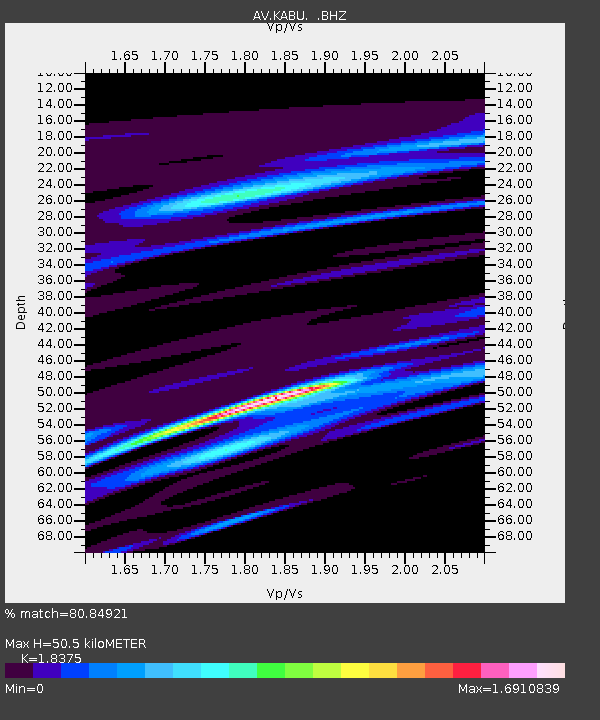
| Estimated Moho Depth: |
50.5 km |
| Estimated Crust Vp/Vs: |
1.84 |
| Assumed Crust Vp: |
6.438 km/s |
| Estimated Crust Vs: |
3.504 km/s |
| Estimated Crust Poisson's Ratio: |
0.29 |
|
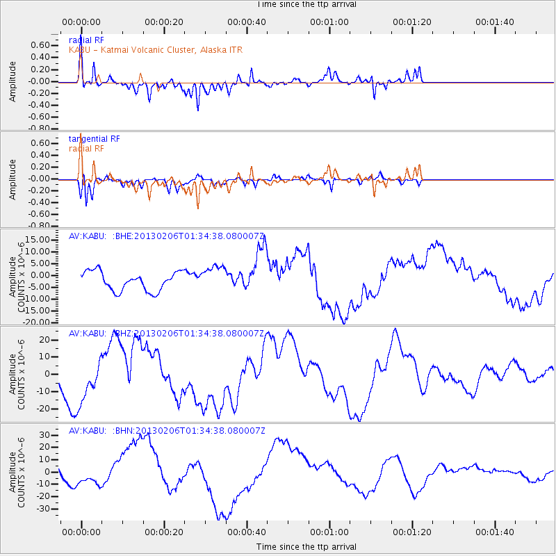
| Radial Match: |
80.84921 % |
| Radial Bump: |
400 |
| Transverse Match: |
66.07585 % |
| Transverse Bump: |
326 |
| SOD ConfigId: |
494114 |
| Insert Time: |
2013-05-01 04:56:05.001 +0000 |
| GWidth: |
2.5 |
| Max Bumps: |
400 |
| Tol: |
0.001 |
|
Signal To Noise
| Channel | StoN | STA | LTA |
| AV:KABU: :BHZ:20130206T01:34:38.080007Z | 2.7542334 | 1.19906035E-5 | 4.353518E-6 |
| AV:KABU: :BHN:20130206T01:34:38.080007Z | 0.712916 | 8.336583E-6 | 1.169364E-5 |
| AV:KABU: :BHE:20130206T01:34:38.080007Z | 1.3860233 | 5.482062E-6 | 3.955245E-6 |
| Arrivals |
| Ps | 6.8 SECOND |
| PpPs | 22 SECOND |
| PsPs/PpSs | 28 SECOND |


