You are here: Home > Network List > CI - Caltech Regional Seismic Network Stations List
> Station TIN Tinemaha, Big Pine, CA, USA > Earthquake Result Viewer
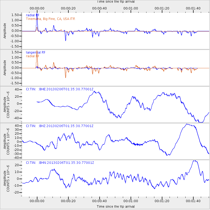
TIN Tinemaha, Big Pine, CA, USA - Earthquake Result Viewer
*The percent match for this event was below the threshold and hence no stack was calculated.
| Earthquake location: |
Santa Cruz Islands Region |
| Earthquake latitude/longitude: |
-11.2/164.9 |
| Earthquake time(UTC): |
2013/02/06 (037) 01:23:19 GMT |
| Earthquake Depth: |
10 km |
| Earthquake Magnitude: |
6.6 MB, 7.1 MW, 7.1 MW |
| Earthquake Catalog/Contributor: |
WHDF/NEIC |
|
| Network: |
CI Caltech Regional Seismic Network |
| Station: |
TIN Tinemaha, Big Pine, CA, USA |
| Lat/Lon: |
37.05 N/118.23 W |
| Elevation: |
1197 m |
|
| Distance: |
86.4 deg |
| Az: |
51.322 deg |
| Baz: |
253.245 deg |
| Ray Param: |
$rayparam |
*The percent match for this event was below the threshold and hence was not used in the summary stack. |
|
| Radial Match: |
70.9507 % |
| Radial Bump: |
258 |
| Transverse Match: |
33.954853 % |
| Transverse Bump: |
400 |
| SOD ConfigId: |
494114 |
| Insert Time: |
2013-05-01 04:58:24.256 +0000 |
| GWidth: |
2.5 |
| Max Bumps: |
400 |
| Tol: |
0.001 |
|
Signal To Noise
| Channel | StoN | STA | LTA |
| CI:TIN: :BHZ:20130206T01:35:30.77001Z | 3.1770766 | 1.1640596E-5 | 3.6639333E-6 |
| CI:TIN: :BHN:20130206T01:35:30.77001Z | 0.7578605 | 2.0964774E-6 | 2.7663102E-6 |
| CI:TIN: :BHE:20130206T01:35:30.77001Z | 1.8179963 | 1.4653783E-5 | 8.060403E-6 |
| Arrivals |
| Ps | |
| PpPs | |
| PsPs/PpSs | |


