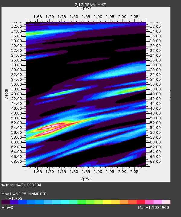
GRAW East Antarctica - Earthquake Result Viewer

Earthquake location: Samoa Islands Region
Earthquake latitude/longitude: -14.8/-175.3
Earthquake time(UTC): 2014/06/29 (180) 15:52:22 GMT
Earthquake Depth: 10 km
Earthquake Magnitude: 6.4 MWW, 6.4 MWB, 6.5 MWC, 6.8 MI
Earthquake Catalog/Contributor: NEIC PDE/NEIC COMCAT
Network: ZJ Transantarctic Mountains Northern Network
Station: GRAW East Antarctica
Lat/Lon: 74.00 S/154.99 E
Elevation: 2205 m
Distance: 61.6 deg
Az: 189.002 deg
Baz: 33.086 deg
Ray Param: 0.06079537
Estimated Moho Depth: 53.25 km
Estimated Crust Vp/Vs: 1.71
Assumed Crust Vp: 6.168 km/s
Estimated Crust Vs: 3.618 km/s
Estimated Crust Poisson's Ratio: 0.24
Radial Match: 91.898384 %
Radial Bump: 400
Transverse Match: 88.514206 %
Transverse Bump: 357
SOD ConfigId: 3390531
Insert Time: 2019-04-12 14:36:36.138 +0000
GWidth: 2.5
Max Bumps: 400
Tol: 0.001

Signal To Noise

ChannelStoNSTALTA
ZJ:GRAW: :HHZ:20140629T16:02:09.880015Z4.80081841.2377894E-62.5782882E-7
ZJ:GRAW: :HHN:20140629T16:02:09.880015Z1.20047912.840978E-72.3665368E-7
ZJ:GRAW: :HHE:20140629T16:02:09.880015Z2.02985674.4686394E-72.2014557E-7
Arrivals
Ps6.4 SECOND
PpPs22 SECOND
PsPs/PpSs29 SECOND