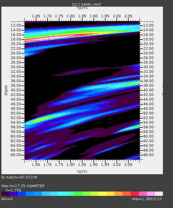
SAMH East Antarctica - Earthquake Result Viewer

Earthquake location: Samoa Islands Region
Earthquake latitude/longitude: -14.8/-175.3
Earthquake time(UTC): 2014/06/29 (180) 15:52:22 GMT
Earthquake Depth: 10 km
Earthquake Magnitude: 6.4 MWW, 6.4 MWB, 6.5 MWC, 6.8 MI
Earthquake Catalog/Contributor: NEIC PDE/NEIC COMCAT
Network: ZJ Transantarctic Mountains Northern Network
Station: SAMH East Antarctica
Lat/Lon: 75.20 S/154.00 E
Elevation: 2087 m
Distance: 62.7 deg
Az: 188.5 deg
Baz: 33.808 deg
Ray Param: 0.06004657
Estimated Moho Depth: 17.25 km
Estimated Crust Vp/Vs: 1.71
Assumed Crust Vp: 6.262 km/s
Estimated Crust Vs: 3.673 km/s
Estimated Crust Poisson's Ratio: 0.24
Radial Match: 93.87229 %
Radial Bump: 310
Transverse Match: 88.25044 %
Transverse Bump: 381
SOD ConfigId: 3390531
Insert Time: 2019-04-12 14:36:40.971 +0000
GWidth: 2.5
Max Bumps: 400
Tol: 0.001

Signal To Noise

ChannelStoNSTALTA
ZJ:SAMH: :HHZ:20140629T16:02:17.640024Z4.62074851.1372243E-62.461126E-7
ZJ:SAMH: :HHN:20140629T16:02:17.640024Z2.10766534.8284267E-72.2908887E-7
ZJ:SAMH: :HHE:20140629T16:02:17.640024Z1.91840743.537152E-71.843796E-7
Arrivals
Ps2.0 SECOND
PpPs7.1 SECOND
PsPs/PpSs9.2 SECOND